You are here: Home > Network List > AK - Alaska Regional Network Stations List
> Station SAMH Samovar Hills, AK, USA > Earthquake Result Viewer
SAMH Samovar Hills, AK, USA - Earthquake Result Viewer
| Earthquake location: |
Solomon Islands |
| Earthquake latitude/longitude: |
-6.4/154.9 |
| Earthquake time(UTC): |
2013/10/16 (289) 10:30:58 GMT |
| Earthquake Depth: |
35 km |
| Earthquake Magnitude: |
6.8 MWW, 6.7 MWB, 6.8 MWW, 6.8 MWC, 7.1 MI |
| Earthquake Catalog/Contributor: |
NEIC PDE/NEIC COMCAT |
|
| Network: |
AK Alaska Regional Network |
| Station: |
SAMH Samovar Hills, AK, USA |
| Lat/Lon: |
60.13 N/140.78 W |
| Elevation: |
1140 m |
|
| Distance: |
83.1 deg |
| Az: |
27.016 deg |
| Baz: |
244.395 deg |
| Ray Param: |
0.04634567 |
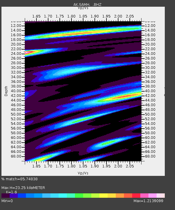
| Estimated Moho Depth: |
23.25 km |
| Estimated Crust Vp/Vs: |
1.60 |
| Assumed Crust Vp: |
6.566 km/s |
| Estimated Crust Vs: |
4.104 km/s |
| Estimated Crust Poisson's Ratio: |
0.18 |
|
| Radial Match: |
85.74838 % |
| Radial Bump: |
400 |
| Transverse Match: |
67.07316 % |
| Transverse Bump: |
400 |
| SOD ConfigId: |
626651 |
| Insert Time: |
2014-04-19 03:51:12.576 +0000 |
| GWidth: |
2.5 |
| Max Bumps: |
400 |
| Tol: |
0.001 |
|

Signal To Noise
| Channel | StoN | STA | LTA |
| AK:SAMH: :BHZ:20131016T10:42:49.807996Z | 37.81205 | 7.9931515E-6 | 2.1139164E-7 |
| AK:SAMH: :BHN:20131016T10:42:49.807996Z | 3.736993 | 1.710588E-6 | 4.577445E-7 |
| AK:SAMH: :BHE:20131016T10:42:49.807996Z | 6.280246 | 2.2653749E-6 | 3.6071438E-7 |
| Arrivals |
| Ps | 2.2 SECOND |
| PpPs | 8.9 SECOND |
| PsPs/PpSs | 11 SECOND |


