You are here: Home > Network List > AK - Alaska Regional Network Stations List
> Station WAT5 Susitna Watana 5, AK, USA > Earthquake Result Viewer
WAT5 Susitna Watana 5, AK, USA - Earthquake Result Viewer
| Earthquake location: |
Solomon Islands |
| Earthquake latitude/longitude: |
-6.4/154.9 |
| Earthquake time(UTC): |
2013/10/16 (289) 10:30:58 GMT |
| Earthquake Depth: |
35 km |
| Earthquake Magnitude: |
6.8 MWW, 6.7 MWB, 6.8 MWW, 6.8 MWC, 7.1 MI |
| Earthquake Catalog/Contributor: |
NEIC PDE/NEIC COMCAT |
|
| Network: |
AK Alaska Regional Network |
| Station: |
WAT5 Susitna Watana 5, AK, USA |
| Lat/Lon: |
63.06 N/148.23 W |
| Elevation: |
1691 m |
|
| Distance: |
81.5 deg |
| Az: |
22.677 deg |
| Baz: |
237.27 deg |
| Ray Param: |
0.04751294 |
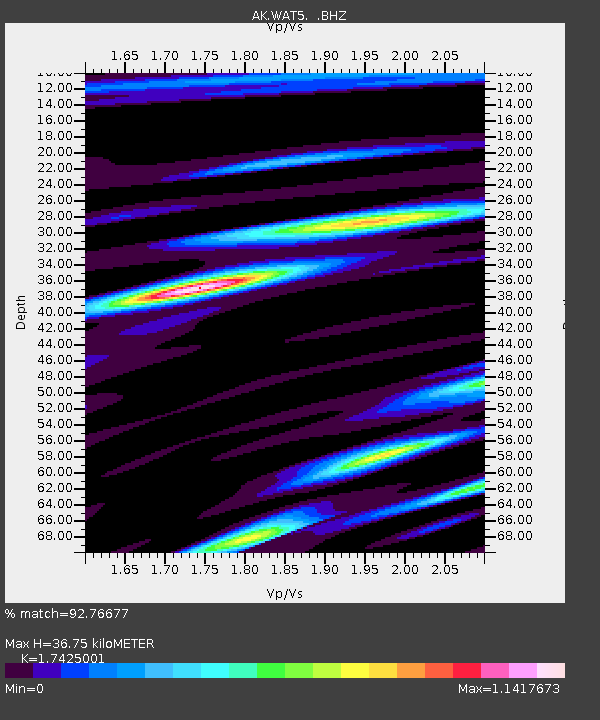
| Estimated Moho Depth: |
36.75 km |
| Estimated Crust Vp/Vs: |
1.74 |
| Assumed Crust Vp: |
6.566 km/s |
| Estimated Crust Vs: |
3.768 km/s |
| Estimated Crust Poisson's Ratio: |
0.25 |
|
| Radial Match: |
92.76677 % |
| Radial Bump: |
400 |
| Transverse Match: |
84.195946 % |
| Transverse Bump: |
400 |
| SOD ConfigId: |
626651 |
| Insert Time: |
2014-04-19 03:51:57.921 +0000 |
| GWidth: |
2.5 |
| Max Bumps: |
400 |
| Tol: |
0.001 |
|

Signal To Noise
| Channel | StoN | STA | LTA |
| AK:WAT5: :BHZ:20131016T10:42:41.068005Z | 42.00999 | 7.0379674E-6 | 1.6753079E-7 |
| AK:WAT5: :BHN:20131016T10:42:41.068005Z | 10.998434 | 1.3878215E-6 | 1.2618356E-7 |
| AK:WAT5: :BHE:20131016T10:42:41.068005Z | 19.26848 | 2.8674513E-6 | 1.4881564E-7 |
| Arrivals |
| Ps | 4.3 SECOND |
| PpPs | 15 SECOND |
| PsPs/PpSs | 19 SECOND |


