You are here: Home > Network List > AZ - ANZA Regional Network Stations List
> Station MONP2 Monument Peak TA Vault, Mt. Laguna, CA, USA > Earthquake Result Viewer
MONP2 Monument Peak TA Vault, Mt. Laguna, CA, USA - Earthquake Result Viewer
| Earthquake location: |
Solomon Islands |
| Earthquake latitude/longitude: |
-6.4/154.9 |
| Earthquake time(UTC): |
2013/10/16 (289) 10:30:58 GMT |
| Earthquake Depth: |
35 km |
| Earthquake Magnitude: |
6.8 MWW, 6.7 MWB, 6.8 MWW, 6.8 MWC, 7.1 MI |
| Earthquake Catalog/Contributor: |
NEIC PDE/NEIC COMCAT |
|
| Network: |
AZ ANZA Regional Network |
| Station: |
MONP2 Monument Peak TA Vault, Mt. Laguna, CA, USA |
| Lat/Lon: |
32.89 N/116.42 W |
| Elevation: |
1000 m |
|
| Distance: |
92.3 deg |
| Az: |
57.332 deg |
| Baz: |
263.881 deg |
| Ray Param: |
0.04146648 |
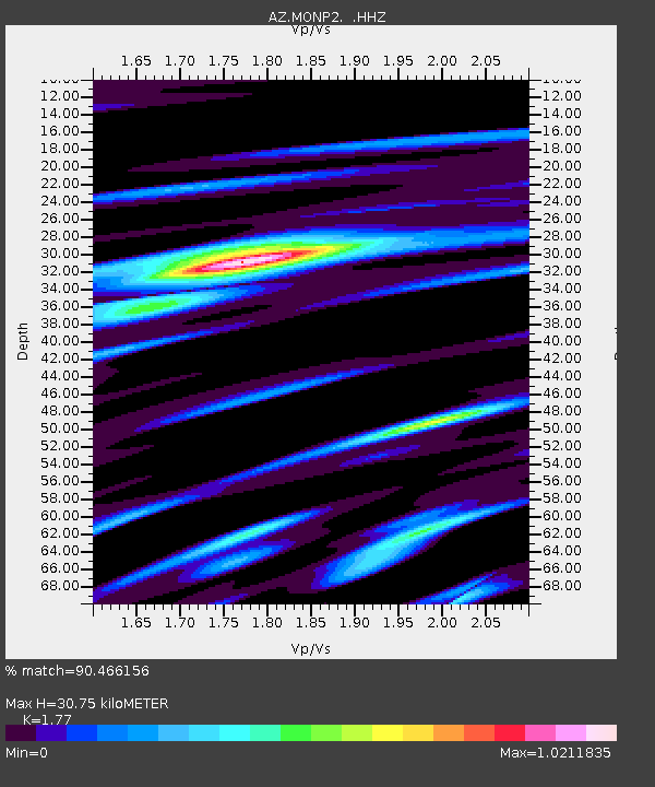
| Estimated Moho Depth: |
30.75 km |
| Estimated Crust Vp/Vs: |
1.77 |
| Assumed Crust Vp: |
6.264 km/s |
| Estimated Crust Vs: |
3.539 km/s |
| Estimated Crust Poisson's Ratio: |
0.27 |
|
| Radial Match: |
90.466156 % |
| Radial Bump: |
336 |
| Transverse Match: |
72.164986 % |
| Transverse Bump: |
358 |
| SOD ConfigId: |
626651 |
| Insert Time: |
2014-04-19 03:55:03.923 +0000 |
| GWidth: |
2.5 |
| Max Bumps: |
400 |
| Tol: |
0.001 |
|

Signal To Noise
| Channel | StoN | STA | LTA |
| AZ:MONP2: :HHZ:20131016T10:43:33.907971Z | 19.105787 | 2.4810283E-6 | 1.2985743E-7 |
| AZ:MONP2: :HHN:20131016T10:43:33.907971Z | 0.9290014 | 1.992747E-7 | 2.145042E-7 |
| AZ:MONP2: :HHE:20131016T10:43:33.907971Z | 4.687137 | 7.977117E-7 | 1.7019167E-7 |
| Arrivals |
| Ps | 3.9 SECOND |
| PpPs | 13 SECOND |
| PsPs/PpSs | 17 SECOND |


