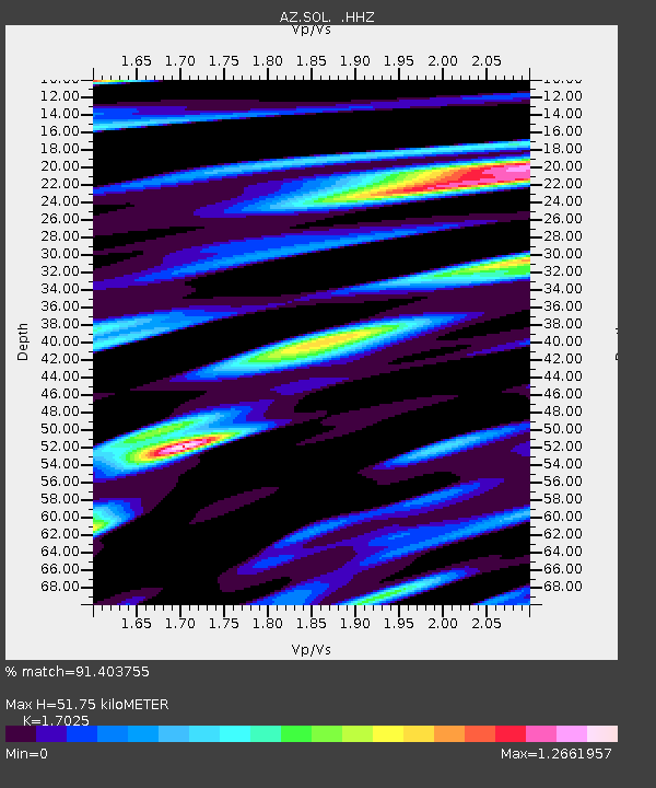
SOL AZ.SOL - Earthquake Result Viewer

Earthquake location: Solomon Islands
Earthquake latitude/longitude: -6.4/154.9
Earthquake time(UTC): 2013/10/16 (289) 10:30:58 GMT
Earthquake Depth: 35 km
Earthquake Magnitude: 6.8 MWW, 6.7 MWB, 6.8 MWW, 6.8 MWC, 7.1 MI
Earthquake Catalog/Contributor: NEIC PDE/NEIC COMCAT
Network: AZ ANZA Regional Network
Station: SOL AZ.SOL
Lat/Lon: 32.84 N/117.25 W
Elevation: 245 m
Distance: 91.6 deg
Az: 57.305 deg
Baz: 263.436 deg
Ray Param: 0.041572
Estimated Moho Depth: 51.75 km
Estimated Crust Vp/Vs: 1.70
Assumed Crust Vp: 6.264 km/s
Estimated Crust Vs: 3.679 km/s
Estimated Crust Poisson's Ratio: 0.24
Radial Match: 91.403755 %
Radial Bump: 288
Transverse Match: 82.12194 %
Transverse Bump: 372
SOD ConfigId: 626651
Insert Time: 2014-04-19 03:55:26.150 +0000
GWidth: 2.5
Max Bumps: 400
Tol: 0.001

Signal To Noise

ChannelStoNSTALTA
AZ:SOL: :HHZ:20131016T10:43:30.69801Z14.3740554.027879E-62.8021873E-7
AZ:SOL: :HHN:20131016T10:43:30.69801Z1.38683079.3422193E-76.7363806E-7
AZ:SOL: :HHE:20131016T10:43:30.69801Z2.68918851.1284275E-64.1961636E-7
Arrivals
Ps5.9 SECOND
PpPs22 SECOND
PsPs/PpSs28 SECOND