You are here: Home > Network List > BK - Berkeley Digital Seismograph Network Stations List
> Station MCCM Marconi Conference Center, Marshall, CA, USA > Earthquake Result Viewer
MCCM Marconi Conference Center, Marshall, CA, USA - Earthquake Result Viewer

| Earthquake location: |
Solomon Islands |
| Earthquake latitude/longitude: |
-6.4/154.9 |
| Earthquake time(UTC): |
2013/10/16 (289) 10:30:58 GMT |
| Earthquake Depth: |
35 km |
| Earthquake Magnitude: |
6.8 MWW, 6.7 MWB, 6.8 MWW, 6.8 MWC, 7.1 MI |
| Earthquake Catalog/Contributor: |
NEIC PDE/NEIC COMCAT |
|
| Network: |
BK Berkeley Digital Seismograph Network |
| Station: |
MCCM Marconi Conference Center, Marshall, CA, USA |
| Lat/Lon: |
38.14 N/122.88 W |
| Elevation: |
-7.7 m |
|
| Distance: |
87.8 deg |
| Az: |
51.417 deg |
| Baz: |
260.147 deg |
| Ray Param: |
0.042993236 |
| Estimated Moho Depth: |
23.5 km |
| Estimated Crust Vp/Vs: |
1.82 |
| Assumed Crust Vp: |
6.472 km/s |
| Estimated Crust Vs: |
3.566 km/s |
| Estimated Crust Poisson's Ratio: |
0.28 |
|
| Radial Match: |
87.82551 % |
| Radial Bump: |
258 |
| Transverse Match: |
80.40772 % |
| Transverse Bump: |
386 |
| SOD ConfigId: |
626651 |
| Insert Time: |
2014-04-19 03:55:50.204 +0000 |
| GWidth: |
2.5 |
| Max Bumps: |
400 |
| Tol: |
0.001 |
|
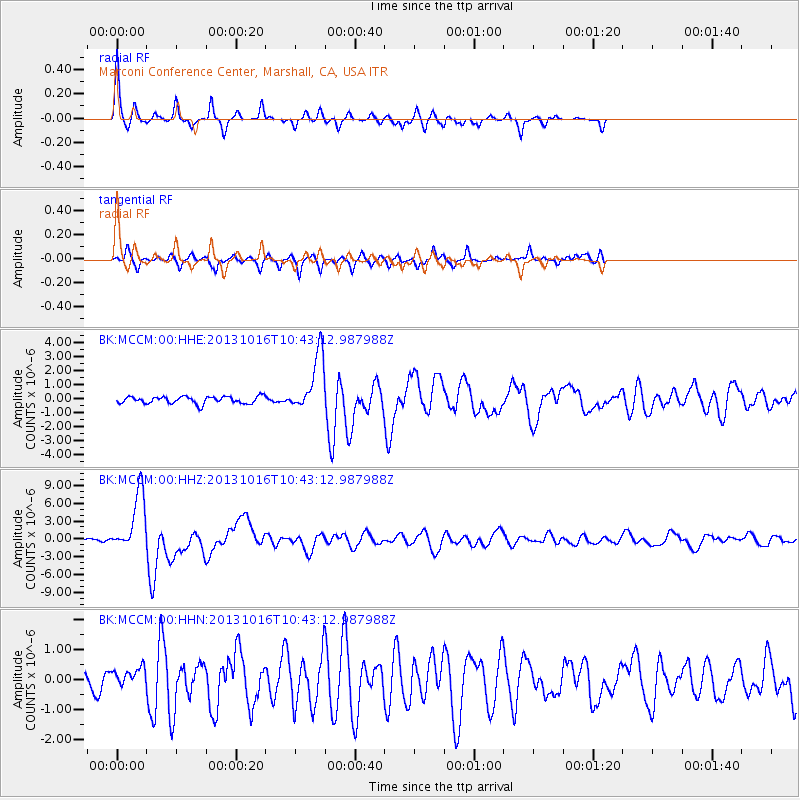
Signal To Noise
| Channel | StoN | STA | LTA |
| BK:MCCM:00:HHZ:20131016T10:43:12.987988Z | 26.187874 | 4.9668515E-6 | 1.8966227E-7 |
| BK:MCCM:00:HHN:20131016T10:43:12.987988Z | 1.4304718 | 3.0693778E-7 | 2.1457102E-7 |
| BK:MCCM:00:HHE:20131016T10:43:12.987988Z | 8.190583 | 2.066622E-6 | 2.5231682E-7 |
| Arrivals |
| Ps | 3.0 SECOND |
| PpPs | 10 SECOND |
| PsPs/PpSs | 13 SECOND |


