You are here: Home > Network List > CB - China National Seismic Network Stations List
> Station XLT Xilinhaote,Neimeng Province > Earthquake Result Viewer
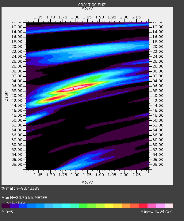
XLT Xilinhaote,Neimeng Province - Earthquake Result Viewer
| Earthquake location: |
Solomon Islands |
| Earthquake latitude/longitude: |
-6.4/154.9 |
| Earthquake time(UTC): |
2013/10/16 (289) 10:30:58 GMT |
| Earthquake Depth: |
35 km |
| Earthquake Magnitude: |
6.8 MWW, 6.7 MWB, 6.8 MWW, 6.8 MWC, 7.1 MI |
| Earthquake Catalog/Contributor: |
NEIC PDE/NEIC COMCAT |
|
| Network: |
CB China National Seismic Network |
| Station: |
XLT Xilinhaote,Neimeng Province |
| Lat/Lon: |
43.90 N/116.08 E |
| Elevation: |
1030 m |
|
| Distance: |
61.2 deg |
| Az: |
328.823 deg |
| Baz: |
134.629 deg |
| Ray Param: |
0.060994353 |
| Estimated Moho Depth: |
36.75 km |
| Estimated Crust Vp/Vs: |
1.79 |
| Assumed Crust Vp: |
6.459 km/s |
| Estimated Crust Vs: |
3.604 km/s |
| Estimated Crust Poisson's Ratio: |
0.27 |
|
| Radial Match: |
93.43183 % |
| Radial Bump: |
267 |
| Transverse Match: |
76.62918 % |
| Transverse Bump: |
400 |
| SOD ConfigId: |
626651 |
| Insert Time: |
2014-04-19 03:56:31.916 +0000 |
| GWidth: |
2.5 |
| Max Bumps: |
400 |
| Tol: |
0.001 |
|

Signal To Noise
| Channel | StoN | STA | LTA |
| CB:XLT:00:BHZ:20131016T10:40:38.78999Z | 18.726786 | 5.1142656E-6 | 2.7309898E-7 |
| CB:XLT:00:BHN:20131016T10:40:38.78999Z | 8.324769 | 1.6828841E-6 | 2.0215384E-7 |
| CB:XLT:00:BHE:20131016T10:40:38.78999Z | 6.6766086 | 1.7741453E-6 | 2.6572553E-7 |
| Arrivals |
| Ps | 4.7 SECOND |
| PpPs | 15 SECOND |
| PsPs/PpSs | 20 SECOND |


