You are here: Home > Network List > G - GEOSCOPE Stations List
> Station TAOE Taiohae, Marquises islands > Earthquake Result Viewer
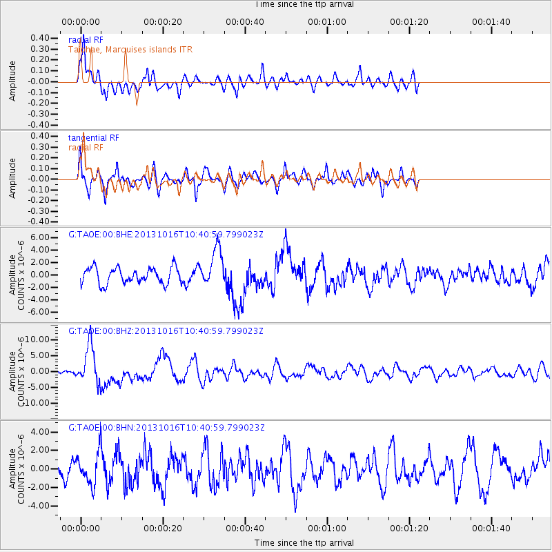
TAOE Taiohae, Marquises islands - Earthquake Result Viewer
*The percent match for this event was below the threshold and hence no stack was calculated.
| Earthquake location: |
Solomon Islands |
| Earthquake latitude/longitude: |
-6.4/154.9 |
| Earthquake time(UTC): |
2013/10/16 (289) 10:30:58 GMT |
| Earthquake Depth: |
35 km |
| Earthquake Magnitude: |
6.8 MWW, 6.7 MWB, 6.8 MWW, 6.8 MWC, 7.1 MI |
| Earthquake Catalog/Contributor: |
NEIC PDE/NEIC COMCAT |
|
| Network: |
G GEOSCOPE |
| Station: |
TAOE Taiohae, Marquises islands |
| Lat/Lon: |
8.85 S/140.15 W |
| Elevation: |
800 m |
|
| Distance: |
64.3 deg |
| Az: |
96.707 deg |
| Baz: |
267.088 deg |
| Ray Param: |
$rayparam |
*The percent match for this event was below the threshold and hence was not used in the summary stack. |
|
| Radial Match: |
69.50561 % |
| Radial Bump: |
377 |
| Transverse Match: |
73.72093 % |
| Transverse Bump: |
400 |
| SOD ConfigId: |
626651 |
| Insert Time: |
2014-04-19 03:59:03.617 +0000 |
| GWidth: |
2.5 |
| Max Bumps: |
400 |
| Tol: |
0.001 |
|
Signal To Noise
| Channel | StoN | STA | LTA |
| G:TAOE:00:BHZ:20131016T10:40:59.799023Z | 8.673947 | 6.1938003E-6 | 7.140694E-7 |
| G:TAOE:00:BHN:20131016T10:40:59.799023Z | 1.4316838 | 1.7224254E-6 | 1.2030767E-6 |
| G:TAOE:00:BHE:20131016T10:40:59.799023Z | 2.4266613 | 3.1400625E-6 | 1.2939847E-6 |
| Arrivals |
| Ps | |
| PpPs | |
| PsPs/PpSs | |


