You are here: Home > Network List > NN - Western Great Basin/Eastern Sierra Nevada Stations List
> Station VCN Virginia City, Nevada gps > Earthquake Result Viewer
VCN Virginia City, Nevada gps - Earthquake Result Viewer
| Earthquake location: |
Solomon Islands |
| Earthquake latitude/longitude: |
-6.4/154.9 |
| Earthquake time(UTC): |
2013/10/16 (289) 10:30:58 GMT |
| Earthquake Depth: |
35 km |
| Earthquake Magnitude: |
6.8 MWW, 6.7 MWB, 6.8 MWW, 6.8 MWC, 7.1 MI |
| Earthquake Catalog/Contributor: |
NEIC PDE/NEIC COMCAT |
|
| Network: |
NN Western Great Basin/Eastern Sierra Nevada |
| Station: |
VCN Virginia City, Nevada gps |
| Lat/Lon: |
39.30 N/119.65 W |
| Elevation: |
1928 m |
|
| Distance: |
90.5 deg |
| Az: |
50.671 deg |
| Baz: |
262.148 deg |
| Ray Param: |
0.041664522 |
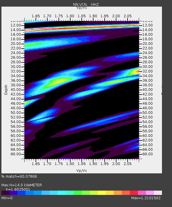
| Estimated Moho Depth: |
14.0 km |
| Estimated Crust Vp/Vs: |
1.60 |
| Assumed Crust Vp: |
6.279 km/s |
| Estimated Crust Vs: |
3.918 km/s |
| Estimated Crust Poisson's Ratio: |
0.18 |
|
| Radial Match: |
80.07988 % |
| Radial Bump: |
400 |
| Transverse Match: |
88.49662 % |
| Transverse Bump: |
400 |
| SOD ConfigId: |
626651 |
| Insert Time: |
2014-04-19 04:04:38.239 +0000 |
| GWidth: |
2.5 |
| Max Bumps: |
400 |
| Tol: |
0.001 |
|

Signal To Noise
| Channel | StoN | STA | LTA |
| NN:VCN: :HHZ:20131016T10:43:25.495007Z | 19.498535 | 2.932964E-6 | 1.5041971E-7 |
| NN:VCN: :HHN:20131016T10:43:25.495007Z | 3.893041 | 4.1907145E-7 | 1.076463E-7 |
| NN:VCN: :HHE:20131016T10:43:25.495007Z | 7.664983 | 6.7727103E-7 | 8.835911E-8 |
| Arrivals |
| Ps | 1.4 SECOND |
| PpPs | 5.7 SECOND |
| PsPs/PpSs | 7.1 SECOND |


