You are here: Home > Network List > TA - USArray Transportable Network (new EarthScope stations) Stations List
> Station D04E Lakebay, WA, USA > Earthquake Result Viewer
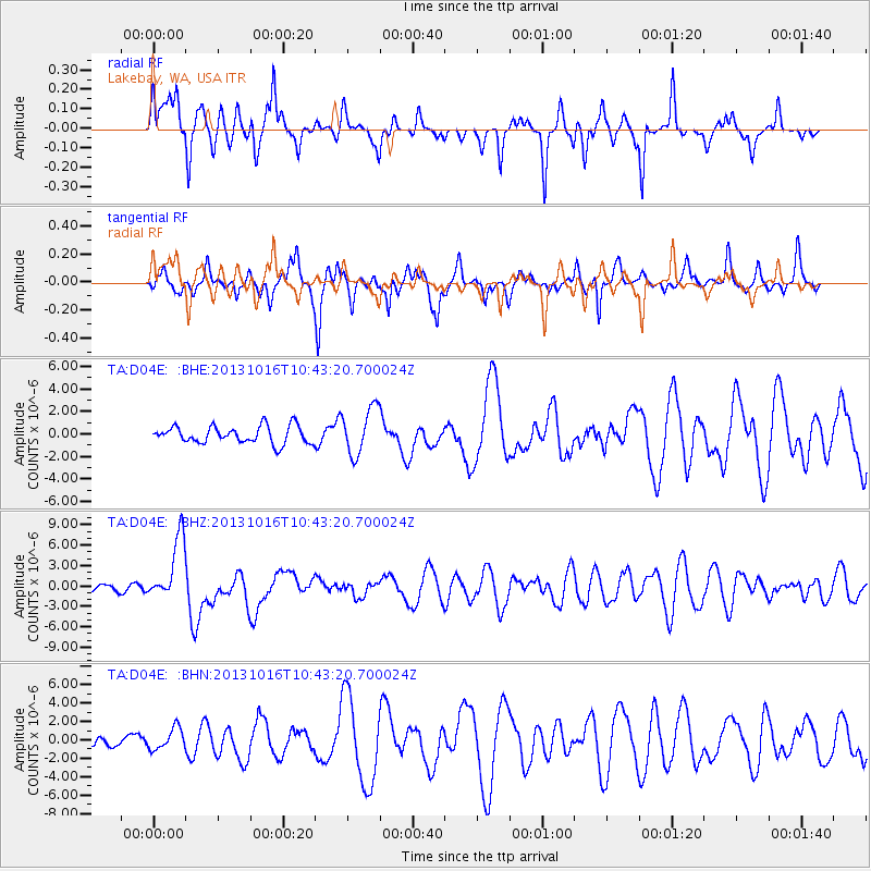
D04E Lakebay, WA, USA - Earthquake Result Viewer
*The percent match for this event was below the threshold and hence no stack was calculated.
| Earthquake location: |
Solomon Islands |
| Earthquake latitude/longitude: |
-6.4/154.9 |
| Earthquake time(UTC): |
2013/10/16 (289) 10:30:58 GMT |
| Earthquake Depth: |
35 km |
| Earthquake Magnitude: |
6.8 MWW, 6.7 MWB, 6.8 MWW, 6.8 MWC, 7.1 MI |
| Earthquake Catalog/Contributor: |
NEIC PDE/NEIC COMCAT |
|
| Network: |
TA USArray Transportable Network (new EarthScope stations) |
| Station: |
D04E Lakebay, WA, USA |
| Lat/Lon: |
47.18 N/122.77 W |
| Elevation: |
45 m |
|
| Distance: |
89.5 deg |
| Az: |
42.535 deg |
| Baz: |
260.01 deg |
| Ray Param: |
$rayparam |
*The percent match for this event was below the threshold and hence was not used in the summary stack. |
|
| Radial Match: |
69.16911 % |
| Radial Bump: |
386 |
| Transverse Match: |
61.00103 % |
| Transverse Bump: |
362 |
| SOD ConfigId: |
626651 |
| Insert Time: |
2014-04-19 04:06:54.318 +0000 |
| GWidth: |
2.5 |
| Max Bumps: |
400 |
| Tol: |
0.001 |
|
Signal To Noise
| Channel | StoN | STA | LTA |
| TA:D04E: :BHZ:20131016T10:43:20.700024Z | 10.777834 | 4.695549E-6 | 4.356672E-7 |
| TA:D04E: :BHN:20131016T10:43:20.700024Z | 1.7016407 | 1.1763802E-6 | 6.913212E-7 |
| TA:D04E: :BHE:20131016T10:43:20.700024Z | 2.7418041 | 2.0894533E-6 | 7.620725E-7 |
| Arrivals |
| Ps | |
| PpPs | |
| PsPs/PpSs | |


