You are here: Home > Network List > TA - USArray Transportable Network (new EarthScope stations) Stations List
> Station E04D Cinebar, WA, USA > Earthquake Result Viewer
E04D Cinebar, WA, USA - Earthquake Result Viewer
| Earthquake location: |
Solomon Islands |
| Earthquake latitude/longitude: |
-6.4/154.9 |
| Earthquake time(UTC): |
2013/10/16 (289) 10:30:58 GMT |
| Earthquake Depth: |
35 km |
| Earthquake Magnitude: |
6.8 MWW, 6.7 MWB, 6.8 MWW, 6.8 MWC, 7.1 MI |
| Earthquake Catalog/Contributor: |
NEIC PDE/NEIC COMCAT |
|
| Network: |
TA USArray Transportable Network (new EarthScope stations) |
| Station: |
E04D Cinebar, WA, USA |
| Lat/Lon: |
46.56 N/122.57 W |
| Elevation: |
204 m |
|
| Distance: |
89.5 deg |
| Az: |
43.172 deg |
| Baz: |
260.165 deg |
| Ray Param: |
0.04176267 |
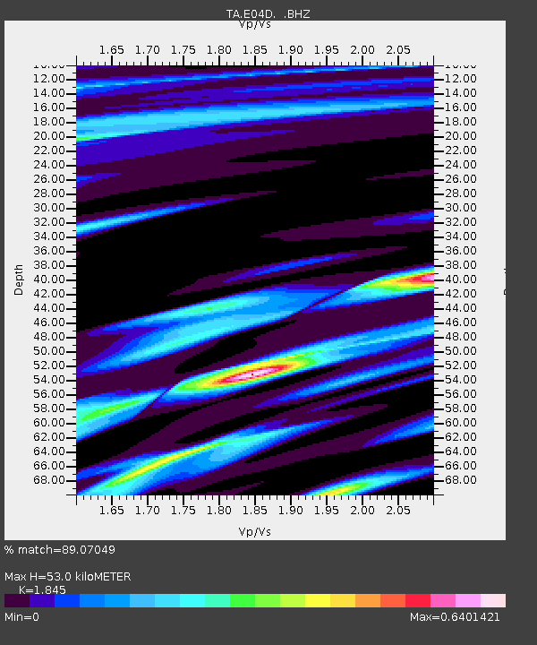
| Estimated Moho Depth: |
53.0 km |
| Estimated Crust Vp/Vs: |
1.85 |
| Assumed Crust Vp: |
6.566 km/s |
| Estimated Crust Vs: |
3.559 km/s |
| Estimated Crust Poisson's Ratio: |
0.29 |
|
| Radial Match: |
89.07049 % |
| Radial Bump: |
360 |
| Transverse Match: |
82.23526 % |
| Transverse Bump: |
400 |
| SOD ConfigId: |
626651 |
| Insert Time: |
2014-04-19 04:06:56.771 +0000 |
| GWidth: |
2.5 |
| Max Bumps: |
400 |
| Tol: |
0.001 |
|

Signal To Noise
| Channel | StoN | STA | LTA |
| TA:E04D: :BHZ:20131016T10:43:20.849988Z | 21.340622 | 3.8753424E-6 | 1.8159464E-7 |
| TA:E04D: :BHN:20131016T10:43:20.849988Z | 2.0172563 | 3.336212E-7 | 1.6538364E-7 |
| TA:E04D: :BHE:20131016T10:43:20.849988Z | 7.9375024 | 1.0761613E-6 | 1.3557934E-7 |
| Arrivals |
| Ps | 7.0 SECOND |
| PpPs | 22 SECOND |
| PsPs/PpSs | 29 SECOND |


