You are here: Home > Network List > TA - USArray Transportable Network (new EarthScope stations) Stations List
> Station G03D McMinnville, OR, USA > Earthquake Result Viewer
G03D McMinnville, OR, USA - Earthquake Result Viewer
| Earthquake location: |
Solomon Islands |
| Earthquake latitude/longitude: |
-6.4/154.9 |
| Earthquake time(UTC): |
2013/10/16 (289) 10:30:58 GMT |
| Earthquake Depth: |
35 km |
| Earthquake Magnitude: |
6.8 MWW, 6.7 MWB, 6.8 MWW, 6.8 MWC, 7.1 MI |
| Earthquake Catalog/Contributor: |
NEIC PDE/NEIC COMCAT |
|
| Network: |
TA USArray Transportable Network (new EarthScope stations) |
| Station: |
G03D McMinnville, OR, USA |
| Lat/Lon: |
45.21 N/123.26 W |
| Elevation: |
222 m |
|
| Distance: |
88.8 deg |
| Az: |
44.412 deg |
| Baz: |
259.685 deg |
| Ray Param: |
0.042283524 |
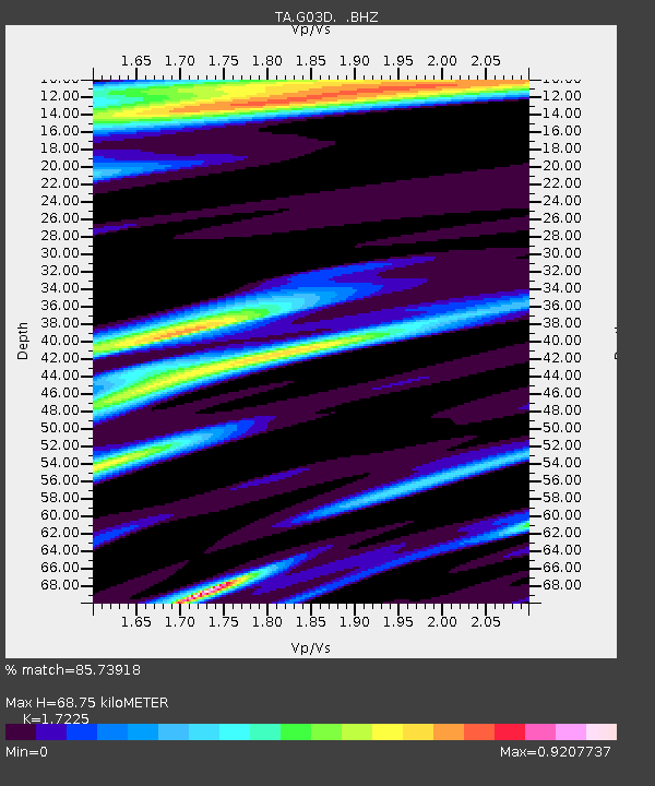
| Estimated Moho Depth: |
68.75 km |
| Estimated Crust Vp/Vs: |
1.72 |
| Assumed Crust Vp: |
6.566 km/s |
| Estimated Crust Vs: |
3.812 km/s |
| Estimated Crust Poisson's Ratio: |
0.25 |
|
| Radial Match: |
85.73918 % |
| Radial Bump: |
400 |
| Transverse Match: |
80.53915 % |
| Transverse Bump: |
400 |
| SOD ConfigId: |
626651 |
| Insert Time: |
2014-04-19 04:07:07.626 +0000 |
| GWidth: |
2.5 |
| Max Bumps: |
400 |
| Tol: |
0.001 |
|
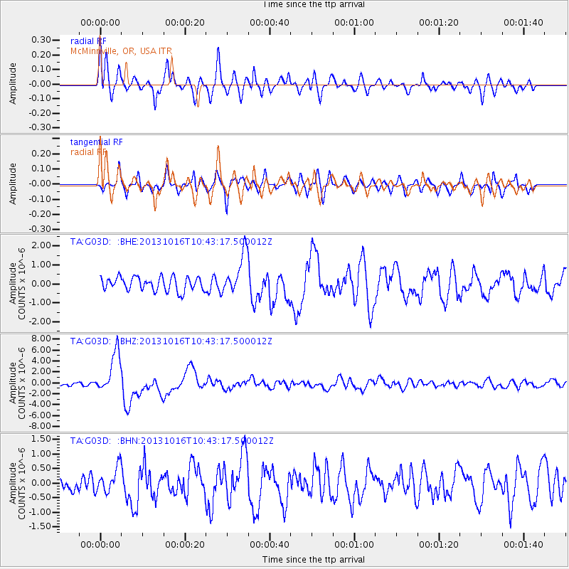
Signal To Noise
| Channel | StoN | STA | LTA |
| TA:G03D: :BHZ:20131016T10:43:17.500012Z | 13.212544 | 3.8770327E-6 | 2.9343573E-7 |
| TA:G03D: :BHN:20131016T10:43:17.500012Z | 1.5177219 | 4.3044986E-7 | 2.8361578E-7 |
| TA:G03D: :BHE:20131016T10:43:17.500012Z | 3.109181 | 1.1096905E-6 | 3.5690766E-7 |
| Arrivals |
| Ps | 7.7 SECOND |
| PpPs | 28 SECOND |
| PsPs/PpSs | 36 SECOND |


