You are here: Home > Network List > TA - USArray Transportable Network (new EarthScope stations) Stations List
> Station L04D Klamath Falls, OR, USA > Earthquake Result Viewer
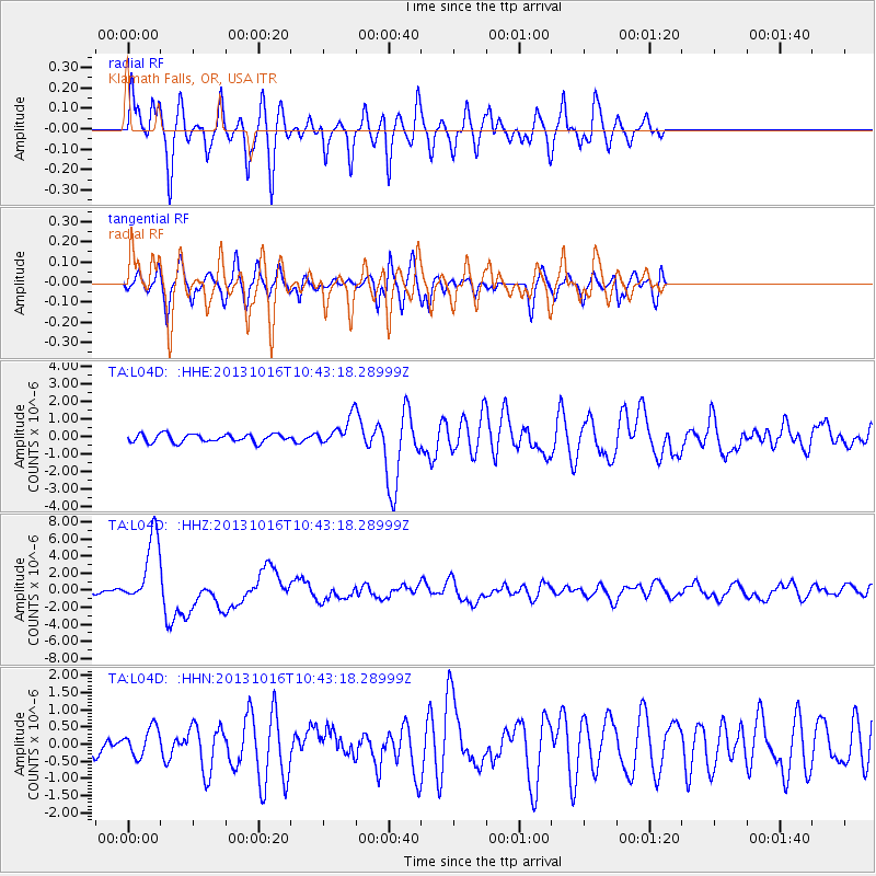
L04D Klamath Falls, OR, USA - Earthquake Result Viewer
*The percent match for this event was below the threshold and hence no stack was calculated.
| Earthquake location: |
Solomon Islands |
| Earthquake latitude/longitude: |
-6.4/154.9 |
| Earthquake time(UTC): |
2013/10/16 (289) 10:30:58 GMT |
| Earthquake Depth: |
35 km |
| Earthquake Magnitude: |
6.8 MWW, 6.7 MWB, 6.8 MWW, 6.8 MWC, 7.1 MI |
| Earthquake Catalog/Contributor: |
NEIC PDE/NEIC COMCAT |
|
| Network: |
TA USArray Transportable Network (new EarthScope stations) |
| Station: |
L04D Klamath Falls, OR, USA |
| Lat/Lon: |
42.22 N/122.30 W |
| Elevation: |
1437 m |
|
| Distance: |
89.0 deg |
| Az: |
47.48 deg |
| Baz: |
260.406 deg |
| Ray Param: |
$rayparam |
*The percent match for this event was below the threshold and hence was not used in the summary stack. |
|
| Radial Match: |
86.20663 % |
| Radial Bump: |
400 |
| Transverse Match: |
75.68833 % |
| Transverse Bump: |
368 |
| SOD ConfigId: |
626651 |
| Insert Time: |
2014-04-19 04:07:48.786 +0000 |
| GWidth: |
2.5 |
| Max Bumps: |
400 |
| Tol: |
0.001 |
|
Signal To Noise
| Channel | StoN | STA | LTA |
| TA:L04D: :HHZ:20131016T10:43:18.28999Z | 24.703823 | 4.047674E-6 | 1.6384807E-7 |
| TA:L04D: :HHN:20131016T10:43:18.28999Z | 1.7100141 | 4.1337495E-7 | 2.4173775E-7 |
| TA:L04D: :HHE:20131016T10:43:18.28999Z | 3.2839055 | 7.6551504E-7 | 2.3311118E-7 |
| Arrivals |
| Ps | |
| PpPs | |
| PsPs/PpSs | |


