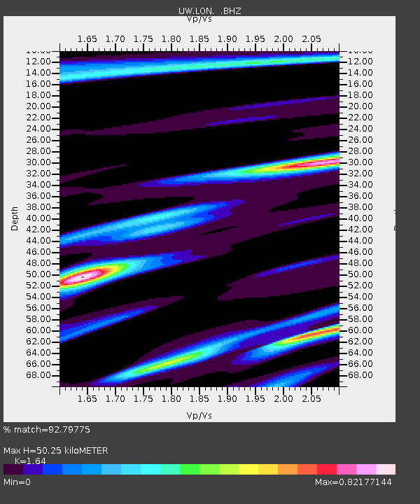
LON Longmire (broad-band and DWWSSN) - Earthquake Result Viewer
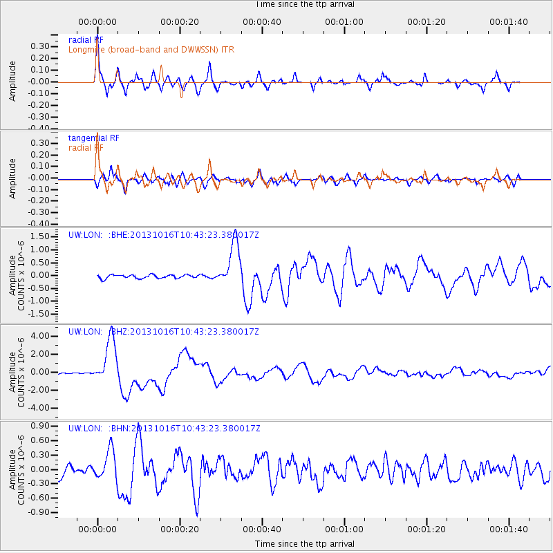
Earthquake location: Solomon Islands
Earthquake latitude/longitude: -6.4/154.9
Earthquake time(UTC): 2013/10/16 (289) 10:30:58 GMT
Earthquake Depth: 35 km
Earthquake Magnitude: 6.8 MWW, 6.7 MWB, 6.8 MWW, 6.8 MWC, 7.1 MI
Earthquake Catalog/Contributor: NEIC PDE/NEIC COMCAT
Network: UW Pacific Northwest Regional Seismic Network
Station: LON Longmire (broad-band and DWWSSN)
Lat/Lon: 46.75 N/121.81 W
Elevation: 850 m
Distance: 90.0 deg
Az: 43.068 deg
Baz: 260.713 deg
Ray Param: 0.04169717
Estimated Moho Depth: 50.25 km
Estimated Crust Vp/Vs: 1.64
Assumed Crust Vp: 6.597 km/s
Estimated Crust Vs: 4.023 km/s
Estimated Crust Poisson's Ratio: 0.20
Radial Match: 92.79775 %
Radial Bump: 400
Transverse Match: 74.53959 %
Transverse Bump: 400
SOD ConfigId: 626651
Insert Time: 2014-04-19 04:11:04.344 +0000
GWidth: 2.5
Max Bumps: 400
Tol: 0.001

Signal To Noise

ChannelStoNSTALTA
UW:LON: :BHZ:20131016T10:43:23.380017Z37.320382.6277955E-67.041181E-8
UW:LON: :BHN:20131016T10:43:23.380017Z3.6401643.2130168E-78.826572E-8
UW:LON: :BHE:20131016T10:43:23.380017Z13.243189.002411E-76.7977716E-8
Arrivals
Ps5.0 SECOND
PpPs20 SECOND
PsPs/PpSs25 SECOND