You are here: Home > Network List > CI - Caltech Regional Seismic Network Stations List
> Station TIN Tinemaha, California, USA > Earthquake Result Viewer
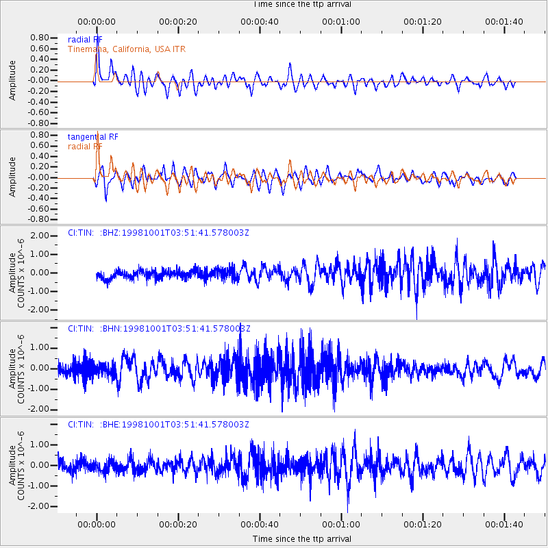
TIN Tinemaha, California, USA - Earthquake Result Viewer
*The percent match for this event was below the threshold and hence no stack was calculated.
| Earthquake location: |
Northern Mid-Atlantic Ridge |
| Earthquake latitude/longitude: |
13.7/-45.6 |
| Earthquake time(UTC): |
1998/10/01 (274) 03:41:13 GMT |
| Earthquake Depth: |
10 km |
| Earthquake Magnitude: |
5.4 MB, 5.5 MS, 6.1 UNKNOWN, 5.9 MW |
| Earthquake Catalog/Contributor: |
WHDF/NEIC |
|
| Network: |
CI Caltech Regional Seismic Network |
| Station: |
TIN Tinemaha, California, USA |
| Lat/Lon: |
37.05 N/118.23 W |
| Elevation: |
1164 m |
|
| Distance: |
68.1 deg |
| Az: |
304.599 deg |
| Baz: |
89.07 deg |
| Ray Param: |
$rayparam |
*The percent match for this event was below the threshold and hence was not used in the summary stack. |
|
| Radial Match: |
72.34866 % |
| Radial Bump: |
400 |
| Transverse Match: |
70.12691 % |
| Transverse Bump: |
400 |
| SOD ConfigId: |
4480 |
| Insert Time: |
2010-02-25 20:52:55.691 +0000 |
| GWidth: |
2.5 |
| Max Bumps: |
400 |
| Tol: |
0.001 |
|
Signal To Noise
| Channel | StoN | STA | LTA |
| CI:TIN: :BHN:19981001T03:51:41.578003Z | 1.3437247 | 2.8134212E-7 | 2.0937482E-7 |
| CI:TIN: :BHE:19981001T03:51:41.578003Z | 1.2057781 | 2.7325157E-7 | 2.2661847E-7 |
| CI:TIN: :BHZ:19981001T03:51:41.578003Z | 1.3985426 | 3.0603078E-7 | 2.188212E-7 |
| Arrivals |
| Ps | |
| PpPs | |
| PsPs/PpSs | |


