You are here: Home > Network List > UW - Pacific Northwest Regional Seismic Network Stations List
> Station RATT Rattlesnake Lake, WA > Earthquake Result Viewer
RATT Rattlesnake Lake, WA - Earthquake Result Viewer
| Earthquake location: |
Solomon Islands |
| Earthquake latitude/longitude: |
-6.4/154.9 |
| Earthquake time(UTC): |
2013/10/16 (289) 10:30:58 GMT |
| Earthquake Depth: |
35 km |
| Earthquake Magnitude: |
6.8 MWW, 6.7 MWB, 6.8 MWW, 6.8 MWC, 7.1 MI |
| Earthquake Catalog/Contributor: |
NEIC PDE/NEIC COMCAT |
|
| Network: |
UW Pacific Northwest Regional Seismic Network |
| Station: |
RATT Rattlesnake Lake, WA |
| Lat/Lon: |
47.43 N/121.80 W |
| Elevation: |
440 m |
|
| Distance: |
90.2 deg |
| Az: |
42.402 deg |
| Baz: |
260.72 deg |
| Ray Param: |
0.04168904 |
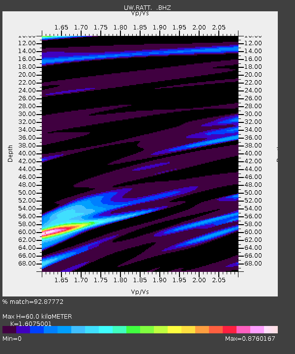
| Estimated Moho Depth: |
60.0 km |
| Estimated Crust Vp/Vs: |
1.61 |
| Assumed Crust Vp: |
6.597 km/s |
| Estimated Crust Vs: |
4.104 km/s |
| Estimated Crust Poisson's Ratio: |
0.18 |
|
| Radial Match: |
92.87772 % |
| Radial Bump: |
349 |
| Transverse Match: |
88.24584 % |
| Transverse Bump: |
400 |
| SOD ConfigId: |
626651 |
| Insert Time: |
2014-04-19 04:11:22.787 +0000 |
| GWidth: |
2.5 |
| Max Bumps: |
400 |
| Tol: |
0.001 |
|

Signal To Noise
| Channel | StoN | STA | LTA |
| UW:RATT: :BHZ:20131016T10:43:23.91499Z | 19.761198 | 3.141561E-6 | 1.5897623E-7 |
| UW:RATT: :BHN:20131016T10:43:23.91499Z | 4.2883077 | 4.5094052E-7 | 1.0515583E-7 |
| UW:RATT: :BHE:20131016T10:43:23.91499Z | 6.8484416 | 9.305363E-7 | 1.3587564E-7 |
| Arrivals |
| Ps | 5.7 SECOND |
| PpPs | 23 SECOND |
| PsPs/PpSs | 29 SECOND |


