You are here: Home > Network List > WY - Yellowstone Wyoming Seismic Network Stations List
> Station YHH Holmes Hill, YNP, WY, USA > Earthquake Result Viewer
YHH Holmes Hill, YNP, WY, USA - Earthquake Result Viewer
| Earthquake location: |
Solomon Islands |
| Earthquake latitude/longitude: |
-6.4/154.9 |
| Earthquake time(UTC): |
2013/10/16 (289) 10:30:58 GMT |
| Earthquake Depth: |
35 km |
| Earthquake Magnitude: |
6.8 MWW, 6.7 MWB, 6.8 MWW, 6.8 MWC, 7.1 MI |
| Earthquake Catalog/Contributor: |
NEIC PDE/NEIC COMCAT |
|
| Network: |
WY Yellowstone Wyoming Seismic Network |
| Station: |
YHH Holmes Hill, YNP, WY, USA |
| Lat/Lon: |
44.79 N/110.85 W |
| Elevation: |
2717 m |
|
| Distance: |
97.5 deg |
| Az: |
45.746 deg |
| Baz: |
268.377 deg |
| Ray Param: |
0.040180966 |
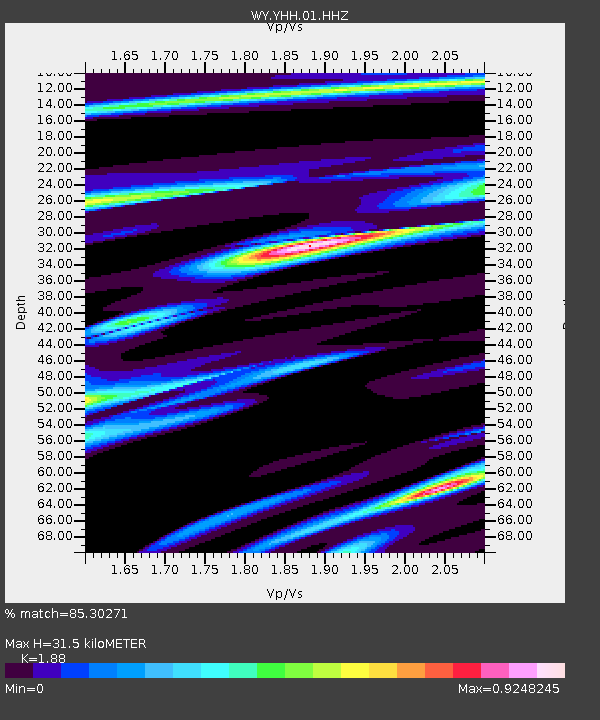
| Estimated Moho Depth: |
31.5 km |
| Estimated Crust Vp/Vs: |
1.88 |
| Assumed Crust Vp: |
6.35 km/s |
| Estimated Crust Vs: |
3.378 km/s |
| Estimated Crust Poisson's Ratio: |
0.30 |
|
| Radial Match: |
85.30271 % |
| Radial Bump: |
269 |
| Transverse Match: |
75.18791 % |
| Transverse Bump: |
318 |
| SOD ConfigId: |
626651 |
| Insert Time: |
2014-04-19 04:11:44.040 +0000 |
| GWidth: |
2.5 |
| Max Bumps: |
400 |
| Tol: |
0.001 |
|
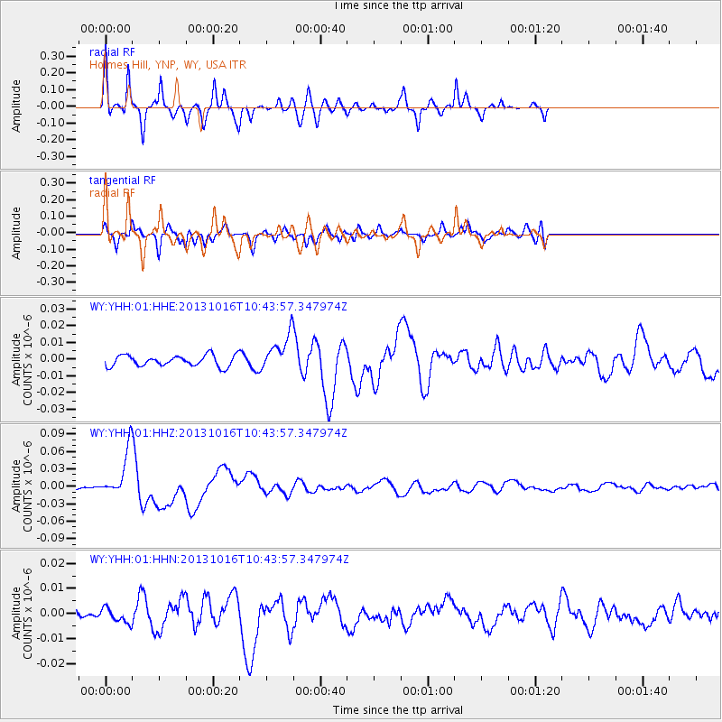
Signal To Noise
| Channel | StoN | STA | LTA |
| WY:YHH:01:HHZ:20131016T10:43:57.347974Z | 19.338486 | 3.9216918E-8 | 2.0279207E-9 |
| WY:YHH:01:HHN:20131016T10:43:57.347974Z | 1.8902601 | 2.875653E-9 | 1.5213002E-9 |
| WY:YHH:01:HHE:20131016T10:43:57.347974Z | 3.334032 | 1.0894667E-8 | 3.2677152E-9 |
| Arrivals |
| Ps | 4.4 SECOND |
| PpPs | 14 SECOND |
| PsPs/PpSs | 18 SECOND |


