You are here: Home > Network List > WY - Yellowstone Wyoming Seismic Network Stations List
> Station YPP Pitchstone Plateau, YNP, WY, USA > Earthquake Result Viewer
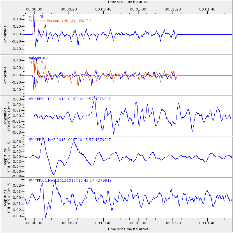
YPP Pitchstone Plateau, YNP, WY, USA - Earthquake Result Viewer
*The percent match for this event was below the threshold and hence no stack was calculated.
| Earthquake location: |
Solomon Islands |
| Earthquake latitude/longitude: |
-6.4/154.9 |
| Earthquake time(UTC): |
2013/10/16 (289) 10:30:58 GMT |
| Earthquake Depth: |
35 km |
| Earthquake Magnitude: |
6.8 MWW, 6.7 MWB, 6.8 MWW, 6.8 MWC, 7.1 MI |
| Earthquake Catalog/Contributor: |
NEIC PDE/NEIC COMCAT |
|
| Network: |
WY Yellowstone Wyoming Seismic Network |
| Station: |
YPP Pitchstone Plateau, YNP, WY, USA |
| Lat/Lon: |
44.27 N/110.80 W |
| Elevation: |
2707 m |
|
| Distance: |
97.5 deg |
| Az: |
46.269 deg |
| Baz: |
268.341 deg |
| Ray Param: |
$rayparam |
*The percent match for this event was below the threshold and hence was not used in the summary stack. |
|
| Radial Match: |
69.09145 % |
| Radial Bump: |
400 |
| Transverse Match: |
77.771675 % |
| Transverse Bump: |
400 |
| SOD ConfigId: |
626651 |
| Insert Time: |
2014-04-19 04:11:57.048 +0000 |
| GWidth: |
2.5 |
| Max Bumps: |
400 |
| Tol: |
0.001 |
|
Signal To Noise
| Channel | StoN | STA | LTA |
| WY:YPP:01:HHZ:20131016T10:43:57.427991Z | 7.150773 | 2.5735542E-8 | 3.5989873E-9 |
| WY:YPP:01:HHN:20131016T10:43:57.427991Z | 4.8338923 | 9.95843E-9 | 2.0601263E-9 |
| WY:YPP:01:HHE:20131016T10:43:57.427991Z | 3.2628975 | 1.2289839E-8 | 3.7665417E-9 |
| Arrivals |
| Ps | |
| PpPs | |
| PsPs/PpSs | |


