You are here: Home > Network List > TA - USArray Transportable Network (new EarthScope stations) Stations List
> Station E54A Lac Daplat, Pontiac, MRC, QC, CAN > Earthquake Result Viewer
E54A Lac Daplat, Pontiac, MRC, QC, CAN - Earthquake Result Viewer
| Earthquake location: |
Gulf Of California |
| Earthquake latitude/longitude: |
26.1/-110.3 |
| Earthquake time(UTC): |
2013/10/19 (292) 17:54:54 GMT |
| Earthquake Depth: |
9.5 km |
| Earthquake Magnitude: |
6.6 MWW, 6.5 MWB, 6.6 MWC, 6.6 MWW, 6.8 MI |
| Earthquake Catalog/Contributor: |
NEIC PDE/NEIC COMCAT |
|
| Network: |
TA USArray Transportable Network (new EarthScope stations) |
| Station: |
E54A Lac Daplat, Pontiac, MRC, QC, CAN |
| Lat/Lon: |
46.43 N/77.19 W |
| Elevation: |
277 m |
|
| Distance: |
33.2 deg |
| Az: |
43.659 deg |
| Baz: |
243.848 deg |
| Ray Param: |
0.07831728 |
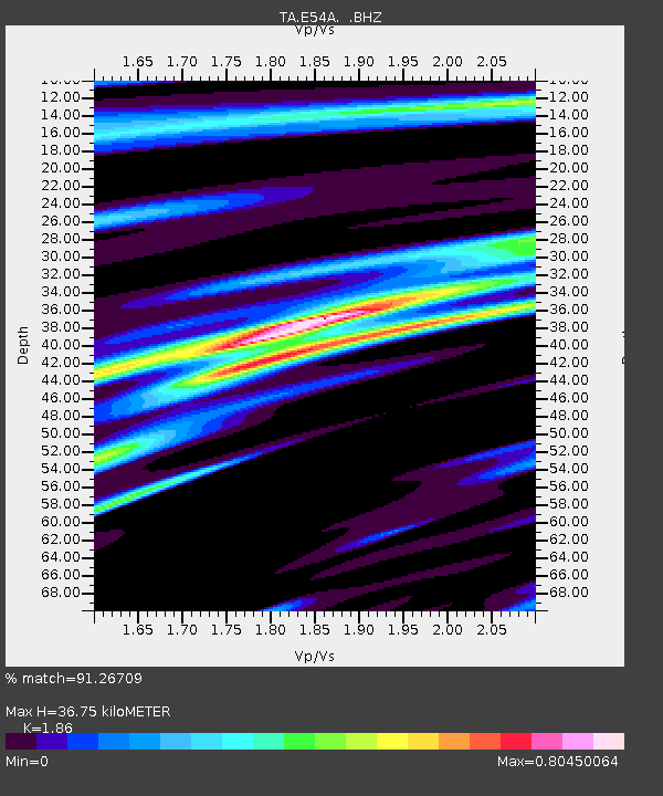
| Estimated Moho Depth: |
36.75 km |
| Estimated Crust Vp/Vs: |
1.86 |
| Assumed Crust Vp: |
6.622 km/s |
| Estimated Crust Vs: |
3.56 km/s |
| Estimated Crust Poisson's Ratio: |
0.30 |
|
| Radial Match: |
91.26709 % |
| Radial Bump: |
266 |
| Transverse Match: |
69.10396 % |
| Transverse Bump: |
400 |
| SOD ConfigId: |
626651 |
| Insert Time: |
2014-04-19 04:23:53.429 +0000 |
| GWidth: |
2.5 |
| Max Bumps: |
400 |
| Tol: |
0.001 |
|
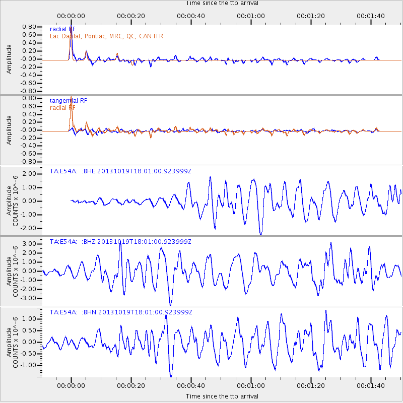
Signal To Noise
| Channel | StoN | STA | LTA |
| TA:E54A: :BHZ:20131019T18:01:00.923999Z | 4.7908807 | 6.0083164E-7 | 1.2541152E-7 |
| TA:E54A: :BHN:20131019T18:01:00.923999Z | 0.76732665 | 1.5145433E-7 | 1.9737921E-7 |
| TA:E54A: :BHE:20131019T18:01:00.923999Z | 2.4124832 | 3.0065883E-7 | 1.2462628E-7 |
| Arrivals |
| Ps | 5.2 SECOND |
| PpPs | 15 SECOND |
| PsPs/PpSs | 20 SECOND |


