You are here: Home > Network List > TA - USArray Transportable Network (new EarthScope stations) Stations List
> Station G58A Ormstown, QC, CAN > Earthquake Result Viewer
G58A Ormstown, QC, CAN - Earthquake Result Viewer
| Earthquake location: |
Gulf Of California |
| Earthquake latitude/longitude: |
26.1/-110.3 |
| Earthquake time(UTC): |
2013/10/19 (292) 17:54:54 GMT |
| Earthquake Depth: |
9.5 km |
| Earthquake Magnitude: |
6.6 MWW, 6.5 MWB, 6.6 MWC, 6.6 MWW, 6.8 MI |
| Earthquake Catalog/Contributor: |
NEIC PDE/NEIC COMCAT |
|
| Network: |
TA USArray Transportable Network (new EarthScope stations) |
| Station: |
G58A Ormstown, QC, CAN |
| Lat/Lon: |
45.15 N/74.05 W |
| Elevation: |
53 m |
|
| Distance: |
34.7 deg |
| Az: |
47.334 deg |
| Baz: |
249.135 deg |
| Ray Param: |
0.077607244 |
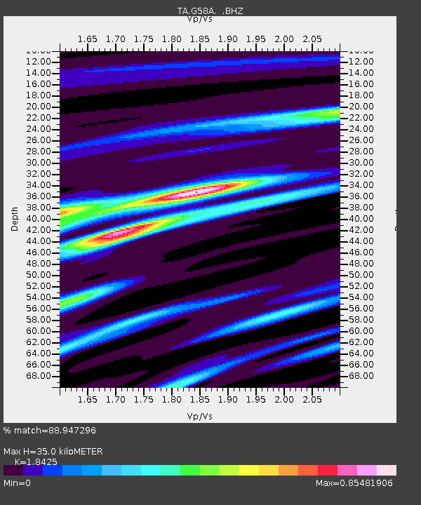
| Estimated Moho Depth: |
35.0 km |
| Estimated Crust Vp/Vs: |
1.84 |
| Assumed Crust Vp: |
6.419 km/s |
| Estimated Crust Vs: |
3.484 km/s |
| Estimated Crust Poisson's Ratio: |
0.29 |
|
| Radial Match: |
88.947296 % |
| Radial Bump: |
326 |
| Transverse Match: |
64.61713 % |
| Transverse Bump: |
400 |
| SOD ConfigId: |
626651 |
| Insert Time: |
2014-04-19 04:24:24.026 +0000 |
| GWidth: |
2.5 |
| Max Bumps: |
400 |
| Tol: |
0.001 |
|
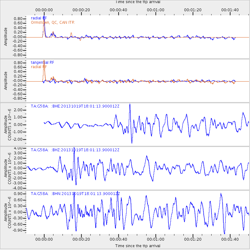
Signal To Noise
| Channel | StoN | STA | LTA |
| TA:G58A: :BHZ:20131019T18:01:13.900012Z | 1.067112 | 2.3463531E-7 | 2.198788E-7 |
| TA:G58A: :BHN:20131019T18:01:13.900012Z | 1.4977272 | 2.1866323E-7 | 1.4599671E-7 |
| TA:G58A: :BHE:20131019T18:01:13.900012Z | 0.5552335 | 1.2917212E-7 | 2.3264468E-7 |
| Arrivals |
| Ps | 4.9 SECOND |
| PpPs | 14 SECOND |
| PsPs/PpSs | 19 SECOND |


