You are here: Home > Network List > TA - USArray Transportable Network (new EarthScope stations) Stations List
> Station L55A Hinsdale, NY, USA > Earthquake Result Viewer
L55A Hinsdale, NY, USA - Earthquake Result Viewer
| Earthquake location: |
Gulf Of California |
| Earthquake latitude/longitude: |
26.1/-110.3 |
| Earthquake time(UTC): |
2013/10/19 (292) 17:54:54 GMT |
| Earthquake Depth: |
9.5 km |
| Earthquake Magnitude: |
6.6 MWW, 6.5 MWB, 6.6 MWC, 6.6 MWW, 6.8 MI |
| Earthquake Catalog/Contributor: |
NEIC PDE/NEIC COMCAT |
|
| Network: |
TA USArray Transportable Network (new EarthScope stations) |
| Station: |
L55A Hinsdale, NY, USA |
| Lat/Lon: |
42.18 N/78.44 W |
| Elevation: |
633 m |
|
| Distance: |
30.7 deg |
| Az: |
50.331 deg |
| Baz: |
248.643 deg |
| Ray Param: |
0.07927313 |
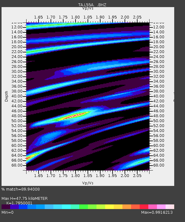
| Estimated Moho Depth: |
47.75 km |
| Estimated Crust Vp/Vs: |
1.80 |
| Assumed Crust Vp: |
6.419 km/s |
| Estimated Crust Vs: |
3.576 km/s |
| Estimated Crust Poisson's Ratio: |
0.27 |
|
| Radial Match: |
89.94008 % |
| Radial Bump: |
254 |
| Transverse Match: |
61.344616 % |
| Transverse Bump: |
400 |
| SOD ConfigId: |
626651 |
| Insert Time: |
2014-04-19 04:25:23.912 +0000 |
| GWidth: |
2.5 |
| Max Bumps: |
400 |
| Tol: |
0.001 |
|
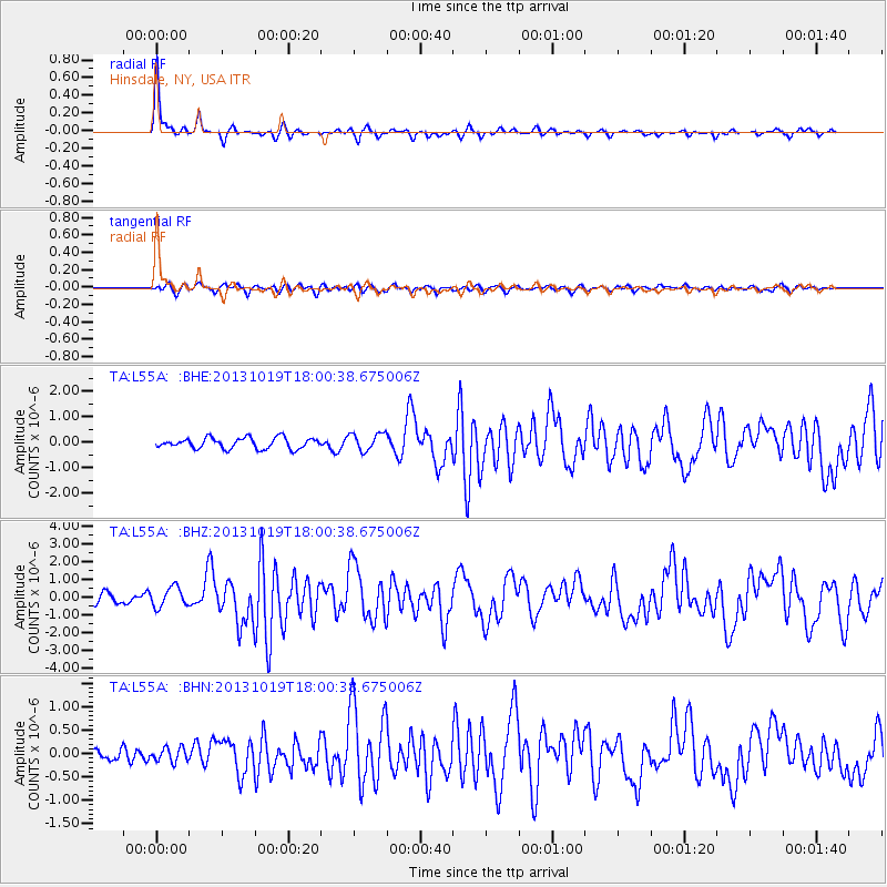
Signal To Noise
| Channel | StoN | STA | LTA |
| TA:L55A: :BHZ:20131019T18:00:38.675006Z | 2.4707692 | 5.566529E-7 | 2.2529538E-7 |
| TA:L55A: :BHN:20131019T18:00:38.675006Z | 1.1250288 | 1.4849805E-7 | 1.3199488E-7 |
| TA:L55A: :BHE:20131019T18:00:38.675006Z | 1.6347978 | 3.4580736E-7 | 2.1152913E-7 |
| Arrivals |
| Ps | 6.4 SECOND |
| PpPs | 19 SECOND |
| PsPs/PpSs | 26 SECOND |


