You are here: Home > Network List > TA - USArray Transportable Network (new EarthScope stations) Stations List
> Station M59A Waymart, PA, USA > Earthquake Result Viewer
M59A Waymart, PA, USA - Earthquake Result Viewer
| Earthquake location: |
Gulf Of California |
| Earthquake latitude/longitude: |
26.1/-110.3 |
| Earthquake time(UTC): |
2013/10/19 (292) 17:54:54 GMT |
| Earthquake Depth: |
9.5 km |
| Earthquake Magnitude: |
6.6 MWW, 6.5 MWB, 6.6 MWC, 6.6 MWW, 6.8 MI |
| Earthquake Catalog/Contributor: |
NEIC PDE/NEIC COMCAT |
|
| Network: |
TA USArray Transportable Network (new EarthScope stations) |
| Station: |
M59A Waymart, PA, USA |
| Lat/Lon: |
41.54 N/75.43 W |
| Elevation: |
471 m |
|
| Distance: |
32.6 deg |
| Az: |
52.898 deg |
| Baz: |
252.827 deg |
| Ray Param: |
0.07859563 |
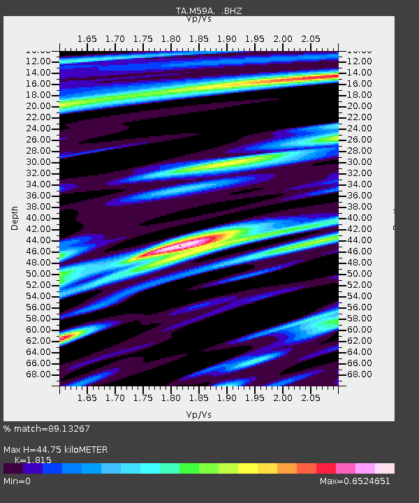
| Estimated Moho Depth: |
44.75 km |
| Estimated Crust Vp/Vs: |
1.82 |
| Assumed Crust Vp: |
6.283 km/s |
| Estimated Crust Vs: |
3.462 km/s |
| Estimated Crust Poisson's Ratio: |
0.28 |
|
| Radial Match: |
89.13267 % |
| Radial Bump: |
400 |
| Transverse Match: |
62.630753 % |
| Transverse Bump: |
400 |
| SOD ConfigId: |
626651 |
| Insert Time: |
2014-04-19 04:25:43.518 +0000 |
| GWidth: |
2.5 |
| Max Bumps: |
400 |
| Tol: |
0.001 |
|
Signal To Noise
| Channel | StoN | STA | LTA |
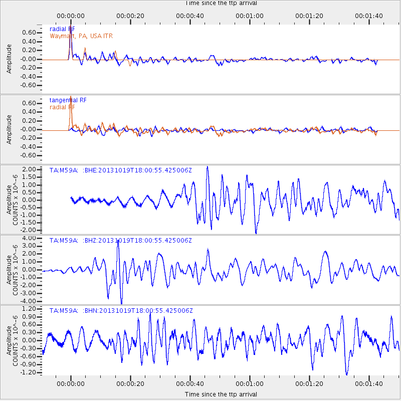
| TA:M59A: :BHZ:20131019T18:00:55.425006Z | 1.5694672 | 2.65071E-7 | 1.6889236E-7 |
| TA:M59A: :BHN:20131019T18:00:55.425006Z | 1.4915881 | 3.3508468E-7 | 2.246496E-7 |
| TA:M59A: :BHE:20131019T18:00:55.425006Z | 2.286097 | 3.6158363E-7 | 1.5816636E-7 |
| Arrivals |
| Ps | 6.2 SECOND |
| PpPs | 19 SECOND |
| PsPs/PpSs | 25 SECOND |


