You are here: Home > Network List > TA - USArray Transportable Network (new EarthScope stations) Stations List
> Station N58A Sunbury, PA, USA > Earthquake Result Viewer
N58A Sunbury, PA, USA - Earthquake Result Viewer
| Earthquake location: |
Gulf Of California |
| Earthquake latitude/longitude: |
26.1/-110.3 |
| Earthquake time(UTC): |
2013/10/19 (292) 17:54:54 GMT |
| Earthquake Depth: |
9.5 km |
| Earthquake Magnitude: |
6.6 MWW, 6.5 MWB, 6.6 MWC, 6.6 MWW, 6.8 MI |
| Earthquake Catalog/Contributor: |
NEIC PDE/NEIC COMCAT |
|
| Network: |
TA USArray Transportable Network (new EarthScope stations) |
| Station: |
N58A Sunbury, PA, USA |
| Lat/Lon: |
40.84 N/76.72 W |
| Elevation: |
200 m |
|
| Distance: |
31.4 deg |
| Az: |
53.618 deg |
| Baz: |
252.595 deg |
| Ray Param: |
0.07906975 |
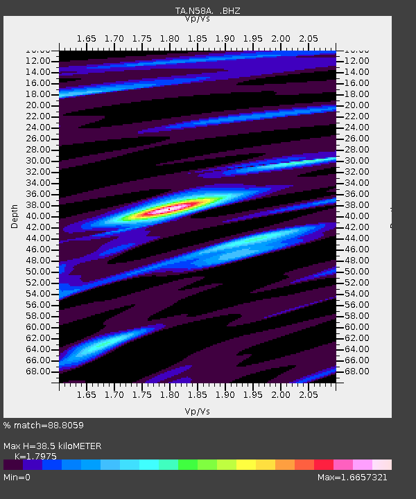
| Estimated Moho Depth: |
38.5 km |
| Estimated Crust Vp/Vs: |
1.80 |
| Assumed Crust Vp: |
6.121 km/s |
| Estimated Crust Vs: |
3.405 km/s |
| Estimated Crust Poisson's Ratio: |
0.28 |
|
| Radial Match: |
88.8059 % |
| Radial Bump: |
317 |
| Transverse Match: |
63.789864 % |
| Transverse Bump: |
400 |
| SOD ConfigId: |
626651 |
| Insert Time: |
2014-04-19 04:25:55.720 +0000 |
| GWidth: |
2.5 |
| Max Bumps: |
400 |
| Tol: |
0.001 |
|

Signal To Noise
| Channel | StoN | STA | LTA |
| TA:N58A: :BHZ:20131019T18:00:45.499988Z | 3.205472 | 5.2369745E-7 | 1.6337609E-7 |
| TA:N58A: :BHN:20131019T18:00:45.499988Z | 1.5838301 | 2.995028E-7 | 1.8910035E-7 |
| TA:N58A: :BHE:20131019T18:00:45.499988Z | 0.93315274 | 1.702452E-7 | 1.8244087E-7 |
| Arrivals |
| Ps | 5.4 SECOND |
| PpPs | 16 SECOND |
| PsPs/PpSs | 22 SECOND |


