You are here: Home > Network List > TA - USArray Transportable Network (new EarthScope stations) Stations List
> Station P58A Pank, Wackersville, MD, USA > Earthquake Result Viewer
P58A Pank, Wackersville, MD, USA - Earthquake Result Viewer
| Earthquake location: |
Gulf Of California |
| Earthquake latitude/longitude: |
26.1/-110.3 |
| Earthquake time(UTC): |
2013/10/19 (292) 17:54:54 GMT |
| Earthquake Depth: |
9.5 km |
| Earthquake Magnitude: |
6.6 MWW, 6.5 MWB, 6.6 MWC, 6.6 MWW, 6.8 MI |
| Earthquake Catalog/Contributor: |
NEIC PDE/NEIC COMCAT |
|
| Network: |
TA USArray Transportable Network (new EarthScope stations) |
| Station: |
P58A Pank, Wackersville, MD, USA |
| Lat/Lon: |
39.49 N/77.30 W |
| Elevation: |
139 m |
|
| Distance: |
30.6 deg |
| Az: |
55.877 deg |
| Baz: |
254.155 deg |
| Ray Param: |
0.079283975 |
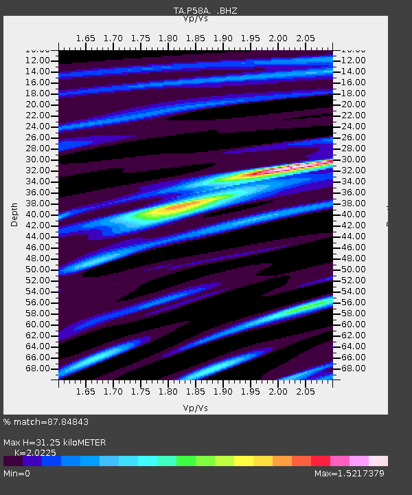
| Estimated Moho Depth: |
31.25 km |
| Estimated Crust Vp/Vs: |
2.02 |
| Assumed Crust Vp: |
6.419 km/s |
| Estimated Crust Vs: |
3.174 km/s |
| Estimated Crust Poisson's Ratio: |
0.34 |
|
| Radial Match: |
87.84843 % |
| Radial Bump: |
392 |
| Transverse Match: |
70.80859 % |
| Transverse Bump: |
400 |
| SOD ConfigId: |
626651 |
| Insert Time: |
2014-04-19 04:26:16.854 +0000 |
| GWidth: |
2.5 |
| Max Bumps: |
400 |
| Tol: |
0.001 |
|

Signal To Noise
| Channel | StoN | STA | LTA |
| TA:P58A: :BHZ:20131019T18:00:38.325Z | 2.2339108 | 2.7259244E-7 | 1.2202476E-7 |
| TA:P58A: :BHN:20131019T18:00:38.325Z | 0.39373598 | 5.8506505E-8 | 1.4859324E-7 |
| TA:P58A: :BHE:20131019T18:00:38.325Z | 1.2699561 | 1.5129022E-7 | 1.19130284E-7 |
| Arrivals |
| Ps | 5.3 SECOND |
| PpPs | 14 SECOND |
| PsPs/PpSs | 19 SECOND |


