You are here: Home > Network List > WI - West Indies IPGP Network Stations List
> Station MPOM Morne Pois, Sainte-Anne, Martinique > Earthquake Result Viewer
MPOM Morne Pois, Sainte-Anne, Martinique - Earthquake Result Viewer
| Earthquake location: |
Gulf Of California |
| Earthquake latitude/longitude: |
26.1/-110.3 |
| Earthquake time(UTC): |
2013/10/19 (292) 17:54:54 GMT |
| Earthquake Depth: |
9.5 km |
| Earthquake Magnitude: |
6.6 MWW, 6.5 MWB, 6.6 MWC, 6.6 MWW, 6.8 MI |
| Earthquake Catalog/Contributor: |
NEIC PDE/NEIC COMCAT |
|
| Network: |
WI West Indies IPGP Network |
| Station: |
MPOM Morne Pois, Sainte-Anne, Martinique |
| Lat/Lon: |
14.45 N/60.86 W |
| Elevation: |
50 m |
|
| Distance: |
47.6 deg |
| Az: |
94.078 deg |
| Baz: |
292.198 deg |
| Ray Param: |
0.06990395 |
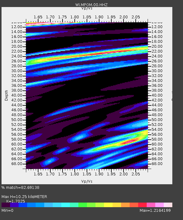
| Estimated Moho Depth: |
10.25 km |
| Estimated Crust Vp/Vs: |
1.70 |
| Assumed Crust Vp: |
5.88 km/s |
| Estimated Crust Vs: |
3.454 km/s |
| Estimated Crust Poisson's Ratio: |
0.24 |
|
| Radial Match: |
82.69138 % |
| Radial Bump: |
400 |
| Transverse Match: |
84.84468 % |
| Transverse Bump: |
400 |
| SOD ConfigId: |
626651 |
| Insert Time: |
2014-04-19 04:27:06.411 +0000 |
| GWidth: |
2.5 |
| Max Bumps: |
400 |
| Tol: |
0.001 |
|

Signal To Noise
| Channel | StoN | STA | LTA |
| WI:MPOM:00:HHZ:20131019T18:02:59.529987Z | 2.3869646 | 5.9486314E-7 | 2.4921323E-7 |
| WI:MPOM:00:HHN:20131019T18:02:59.529987Z | 1.3145577 | 3.0709643E-7 | 2.33612E-7 |
| WI:MPOM:00:HHE:20131019T18:02:59.529987Z | 1.053979 | 4.5893543E-7 | 4.3543128E-7 |
| Arrivals |
| Ps | 1.3 SECOND |
| PpPs | 4.5 SECOND |
| PsPs/PpSs | 5.8 SECOND |


