You are here: Home > Network List > AZ - ANZA Regional Network Stations List
> Station FRD AZ.FRD > Earthquake Result Viewer
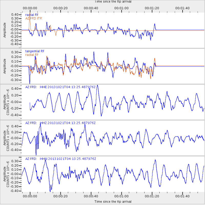
FRD AZ.FRD - Earthquake Result Viewer
*The percent match for this event was below the threshold and hence no stack was calculated.
| Earthquake location: |
Tonga Islands Region |
| Earthquake latitude/longitude: |
-22.9/-174.7 |
| Earthquake time(UTC): |
2013/10/21 (294) 04:01:54 GMT |
| Earthquake Depth: |
12 km |
| Earthquake Magnitude: |
5.5 MWB, 5.6 MWC |
| Earthquake Catalog/Contributor: |
NEIC PDE/NEIC COMCAT |
|
| Network: |
AZ ANZA Regional Network |
| Station: |
FRD AZ.FRD |
| Lat/Lon: |
33.49 N/116.60 W |
| Elevation: |
1164 m |
|
| Distance: |
78.8 deg |
| Az: |
46.324 deg |
| Baz: |
232.924 deg |
| Ray Param: |
$rayparam |
*The percent match for this event was below the threshold and hence was not used in the summary stack. |
|
| Radial Match: |
65.27861 % |
| Radial Bump: |
400 |
| Transverse Match: |
58.64464 % |
| Transverse Bump: |
400 |
| SOD ConfigId: |
626651 |
| Insert Time: |
2014-04-19 04:34:55.425 +0000 |
| GWidth: |
2.5 |
| Max Bumps: |
400 |
| Tol: |
0.001 |
|
Signal To Noise
| Channel | StoN | STA | LTA |
| AZ:FRD: :HHZ:20131021T04:13:25.487976Z | 0.8466184 | 1.6633285E-7 | 1.9646733E-7 |
| AZ:FRD: :HHN:20131021T04:13:25.487976Z | 1.9185455 | 1.622174E-7 | 8.455228E-8 |
| AZ:FRD: :HHE:20131021T04:13:25.487976Z | 1.2301877 | 1.9639481E-7 | 1.5964622E-7 |
| Arrivals |
| Ps | |
| PpPs | |
| PsPs/PpSs | |


