You are here: Home > Network List > TA - USArray Transportable Network (new EarthScope stations) Stations List
> Station D04E Lakebay, WA, USA > Earthquake Result Viewer
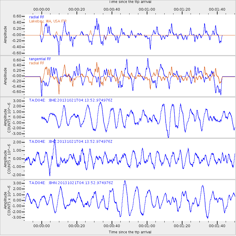
D04E Lakebay, WA, USA - Earthquake Result Viewer
*The percent match for this event was below the threshold and hence no stack was calculated.
| Earthquake location: |
Tonga Islands Region |
| Earthquake latitude/longitude: |
-22.9/-174.7 |
| Earthquake time(UTC): |
2013/10/21 (294) 04:01:54 GMT |
| Earthquake Depth: |
12 km |
| Earthquake Magnitude: |
5.5 MWB, 5.6 MWC |
| Earthquake Catalog/Contributor: |
NEIC PDE/NEIC COMCAT |
|
| Network: |
TA USArray Transportable Network (new EarthScope stations) |
| Station: |
D04E Lakebay, WA, USA |
| Lat/Lon: |
47.18 N/122.77 W |
| Elevation: |
45 m |
|
| Distance: |
84.0 deg |
| Az: |
32.688 deg |
| Baz: |
226.868 deg |
| Ray Param: |
$rayparam |
*The percent match for this event was below the threshold and hence was not used in the summary stack. |
|
| Radial Match: |
55.19288 % |
| Radial Bump: |
309 |
| Transverse Match: |
61.976597 % |
| Transverse Bump: |
400 |
| SOD ConfigId: |
626651 |
| Insert Time: |
2014-04-19 04:42:17.690 +0000 |
| GWidth: |
2.5 |
| Max Bumps: |
400 |
| Tol: |
0.001 |
|
Signal To Noise
| Channel | StoN | STA | LTA |
| TA:D04E: :BHZ:20131021T04:13:52.974976Z | 2.0205095 | 7.655338E-7 | 3.7888157E-7 |
| TA:D04E: :BHN:20131021T04:13:52.974976Z | 0.65665835 | 5.294118E-7 | 8.062211E-7 |
| TA:D04E: :BHE:20131021T04:13:52.974976Z | 2.319294 | 2.0228513E-6 | 8.721841E-7 |
| Arrivals |
| Ps | |
| PpPs | |
| PsPs/PpSs | |


