You are here: Home > Network List > US - United States National Seismic Network Stations List
> Station CBKS Cedar Bluff, Kansas, USA > Earthquake Result Viewer
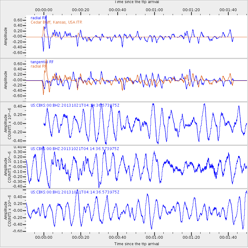
CBKS Cedar Bluff, Kansas, USA - Earthquake Result Viewer
*The percent match for this event was below the threshold and hence no stack was calculated.
| Earthquake location: |
Tonga Islands Region |
| Earthquake latitude/longitude: |
-22.9/-174.7 |
| Earthquake time(UTC): |
2013/10/21 (294) 04:01:54 GMT |
| Earthquake Depth: |
12 km |
| Earthquake Magnitude: |
5.5 MWB, 5.6 MWC |
| Earthquake Catalog/Contributor: |
NEIC PDE/NEIC COMCAT |
|
| Network: |
US United States National Seismic Network |
| Station: |
CBKS Cedar Bluff, Kansas, USA |
| Lat/Lon: |
38.81 N/99.74 W |
| Elevation: |
677 m |
|
| Distance: |
93.2 deg |
| Az: |
49.085 deg |
| Baz: |
243.082 deg |
| Ray Param: |
$rayparam |
*The percent match for this event was below the threshold and hence was not used in the summary stack. |
|
| Radial Match: |
82.18837 % |
| Radial Bump: |
400 |
| Transverse Match: |
66.188614 % |
| Transverse Bump: |
400 |
| SOD ConfigId: |
626651 |
| Insert Time: |
2014-04-19 04:43:34.359 +0000 |
| GWidth: |
2.5 |
| Max Bumps: |
400 |
| Tol: |
0.001 |
|
Signal To Noise
| Channel | StoN | STA | LTA |
| US:CBKS:00:BHZ:20131021T04:14:36.573975Z | 1.9428972 | 2.6457204E-7 | 1.3617398E-7 |
| US:CBKS:00:BH1:20131021T04:14:36.573975Z | 0.7594892 | 1.2477122E-7 | 1.6428308E-7 |
| US:CBKS:00:BH2:20131021T04:14:36.573975Z | 1.6893407 | 3.10995E-7 | 1.8409253E-7 |
| Arrivals |
| Ps | |
| PpPs | |
| PsPs/PpSs | |


