You are here: Home > Network List > US - United States National Seismic Network Stations List
> Station ELK Elko, Nevada, USA > Earthquake Result Viewer
ELK Elko, Nevada, USA - Earthquake Result Viewer
*The percent match for this event was below the threshold and hence no stack was calculated.
| Earthquake location: |
Tonga Islands Region |
| Earthquake latitude/longitude: |
-22.9/-174.7 |
| Earthquake time(UTC): |
2013/10/21 (294) 04:01:54 GMT |
| Earthquake Depth: |
12 km |
| Earthquake Magnitude: |
5.5 MWB, 5.6 MWC |
| Earthquake Catalog/Contributor: |
NEIC PDE/NEIC COMCAT |
|
| Network: |
US United States National Seismic Network |
| Station: |
ELK Elko, Nevada, USA |
| Lat/Lon: |
40.74 N/115.24 W |
| Elevation: |
2210 m |
|
| Distance: |
84.0 deg |
| Az: |
41.149 deg |
| Baz: |
232.973 deg |
| Ray Param: |
$rayparam |
*The percent match for this event was below the threshold and hence was not used in the summary stack. |
|
| Radial Match: |
55.671665 % |
| Radial Bump: |
400 |
| Transverse Match: |
68.5298 % |
| Transverse Bump: |
400 |
| SOD ConfigId: |
626651 |
| Insert Time: |
2014-04-19 04:43:42.461 +0000 |
| GWidth: |
2.5 |
| Max Bumps: |
400 |
| Tol: |
0.001 |
|
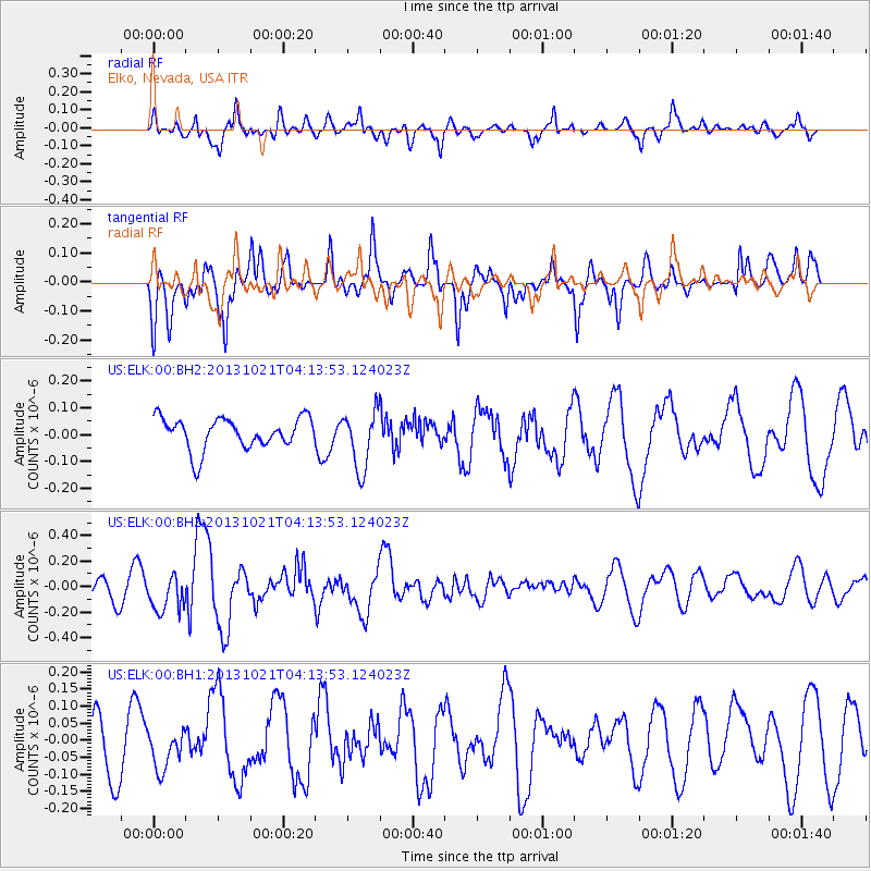
Signal To Noise
| Channel | StoN | STA | LTA |
| US:ELK:00:BHZ:20131021T04:13:53.124023Z | 1.5842271 | 1.4292857E-7 | 9.021975E-8 |
| US:ELK:00:BH1:20131021T04:13:53.124023Z | 0.7179296 | 5.906346E-8 | 8.226915E-8 |
| US:ELK:00:BH2:20131021T04:13:53.124023Z | 1.8747832 | 1.0934759E-7 | 5.832546E-8 |
| Arrivals |
| Ps | |
| PpPs | |
| PsPs/PpSs | |


