You are here: Home > Network List > TA - USArray Transportable Network (new EarthScope stations) Stations List
> Station Y12C Blythe, CA, USA > Earthquake Result Viewer
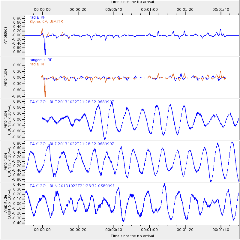
Y12C Blythe, CA, USA - Earthquake Result Viewer
*The percent match for this event was below the threshold and hence no stack was calculated.
| Earthquake location: |
Solomon Islands |
| Earthquake latitude/longitude: |
-6.3/155.0 |
| Earthquake time(UTC): |
2013/10/22 (295) 21:15:51 GMT |
| Earthquake Depth: |
50 km |
| Earthquake Magnitude: |
5.5 MWW, 5.4 MWW, 5.5 MWB, 5.5 MWC |
| Earthquake Catalog/Contributor: |
NEIC PDE/NEIC COMCAT |
|
| Network: |
TA USArray Transportable Network (new EarthScope stations) |
| Station: |
Y12C Blythe, CA, USA |
| Lat/Lon: |
33.75 N/114.52 W |
| Elevation: |
196 m |
|
| Distance: |
93.9 deg |
| Az: |
56.625 deg |
| Baz: |
265.022 deg |
| Ray Param: |
$rayparam |
*The percent match for this event was below the threshold and hence was not used in the summary stack. |
|
| Radial Match: |
86.027916 % |
| Radial Bump: |
332 |
| Transverse Match: |
51.30156 % |
| Transverse Bump: |
400 |
| SOD ConfigId: |
626651 |
| Insert Time: |
2014-04-19 04:56:10.090 +0000 |
| GWidth: |
2.5 |
| Max Bumps: |
400 |
| Tol: |
0.001 |
|
Signal To Noise
| Channel | StoN | STA | LTA |
| TA:Y12C: :BHZ:20131022T21:28:32.068999Z | 1.8053067 | 4.2810706E-7 | 2.3713812E-7 |
| TA:Y12C: :BHN:20131022T21:28:32.068999Z | 1.2123045 | 1.5387879E-7 | 1.2693081E-7 |
| TA:Y12C: :BHE:20131022T21:28:32.068999Z | 4.072943 | 5.3211744E-7 | 1.3064691E-7 |
| Arrivals |
| Ps | |
| PpPs | |
| PsPs/PpSs | |


