You are here: Home > Network List > UW - Pacific Northwest Regional Seismic Network Stations List
> Station PASS Maple Falls, WA, USA > Earthquake Result Viewer
PASS Maple Falls, WA, USA - Earthquake Result Viewer
| Earthquake location: |
Solomon Islands |
| Earthquake latitude/longitude: |
-6.3/155.0 |
| Earthquake time(UTC): |
2013/10/22 (295) 21:15:51 GMT |
| Earthquake Depth: |
50 km |
| Earthquake Magnitude: |
5.5 MWW, 5.4 MWW, 5.5 MWB, 5.5 MWC |
| Earthquake Catalog/Contributor: |
NEIC PDE/NEIC COMCAT |
|
| Network: |
UW Pacific Northwest Regional Seismic Network |
| Station: |
PASS Maple Falls, WA, USA |
| Lat/Lon: |
49.00 N/122.09 W |
| Elevation: |
174 m |
|
| Distance: |
90.1 deg |
| Az: |
40.814 deg |
| Baz: |
260.554 deg |
| Ray Param: |
0.041687574 |
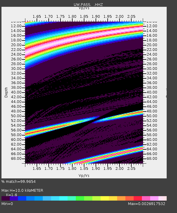
| Estimated Moho Depth: |
10.0 km |
| Estimated Crust Vp/Vs: |
1.60 |
| Assumed Crust Vp: |
6.566 km/s |
| Estimated Crust Vs: |
4.104 km/s |
| Estimated Crust Poisson's Ratio: |
0.18 |
|
| Radial Match: |
99.9654 % |
| Radial Bump: |
5 |
| Transverse Match: |
99.95587 % |
| Transverse Bump: |
6 |
| SOD ConfigId: |
626651 |
| Insert Time: |
2014-04-19 04:57:38.196 +0000 |
| GWidth: |
2.5 |
| Max Bumps: |
400 |
| Tol: |
0.001 |
|
Signal To Noise
| Channel | StoN | STA | LTA |
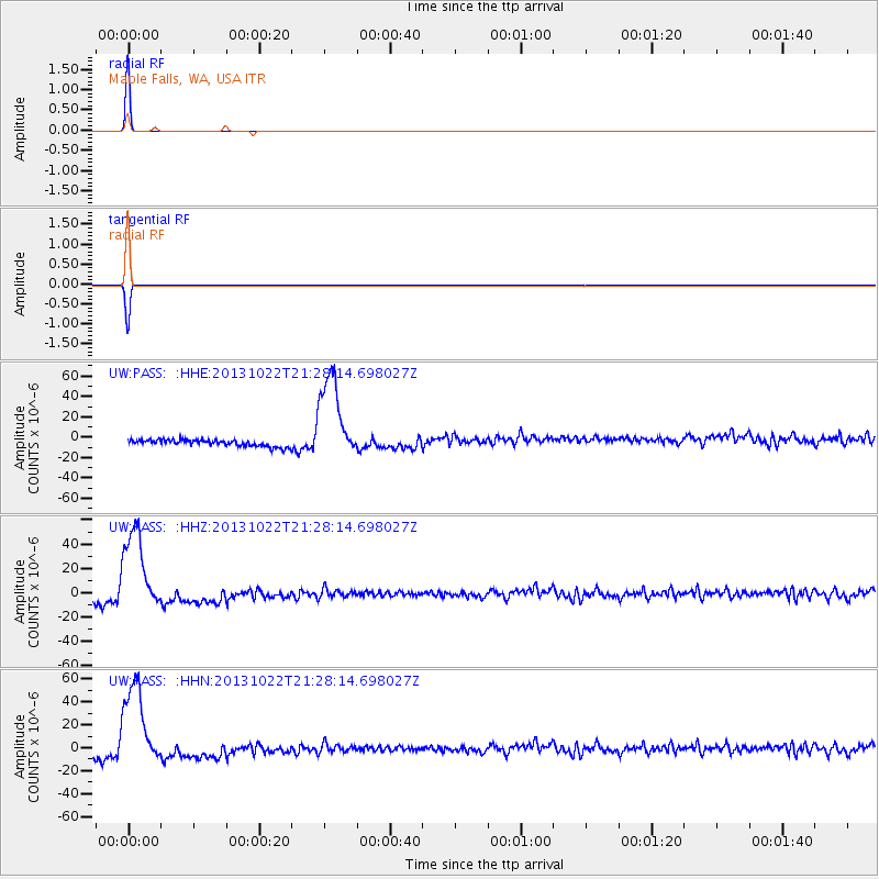
| UW:PASS: :HHZ:20131022T21:28:14.698027Z | 13.868105 | 3.7332957E-5 | 2.6920013E-6 |
| UW:PASS: :HHN:20131022T21:28:14.698027Z | 13.731215 | 4.0015217E-5 | 2.9141788E-6 |
| UW:PASS: :HHE:20131022T21:28:14.698027Z | 13.733547 | 4.3793683E-5 | 3.1888108E-6 |
| Arrivals |
| Ps | 0.9 SECOND |
| PpPs | 3.9 SECOND |
| PsPs/PpSs | 4.8 SECOND |


