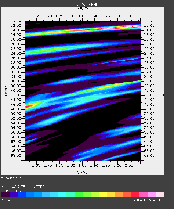
TLY Talaya, Russia - Earthquake Result Viewer

Earthquake location: Southeast Of Loyalty Islands
Earthquake latitude/longitude: -23.0/169.9
Earthquake time(UTC): 1995/05/16 (136) 20:12:45 GMT
Earthquake Depth: 33 km
Earthquake Magnitude: 6.8 MB, 7.7 MS, 7.7 UNKNOWN, 7.7 MW
Earthquake Catalog/Contributor: WHDF/NEIC
Network: II Global Seismograph Network (GSN - IRIS/IDA)
Station: TLY Talaya, Russia
Lat/Lon: 51.68 N/103.64 E
Elevation: 579 m
Distance: 94.2 deg
Az: 325.152 deg
Baz: 122.266 deg
Ray Param: 0.041087408
Estimated Moho Depth: 12.25 km
Estimated Crust Vp/Vs: 2.06
Assumed Crust Vp: 6.419 km/s
Estimated Crust Vs: 3.112 km/s
Estimated Crust Poisson's Ratio: 0.35
Radial Match: 98.83811 %
Radial Bump: 295
Transverse Match: 97.0282 %
Transverse Bump: 400
SOD ConfigId: 61242
Insert Time: 2010-03-01 17:27:21.986 +0000
GWidth: 2.5
Max Bumps: 400
Tol: 0.001

Signal To Noise

ChannelStoNSTALTA
II:TLY:00:BHN:19950516T20:25:29.800012Z4.8680141.543048E-73.169769E-8
II:TLY:00:BHE:19950516T20:25:29.800012Z9.0508192.5906118E-72.8622955E-8
II:TLY:00:BHZ:19950516T20:25:29.800012Z14.951281.0325234E-66.9059205E-8
Arrivals
Ps2.1 SECOND
PpPs5.7 SECOND
PsPs/PpSs7.8 SECOND