You are here: Home > Network List > TA - USArray Transportable Network (new EarthScope stations) Stations List
> Station I59A Olmsteadville, NY, USA > Earthquake Result Viewer
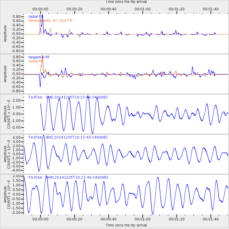
I59A Olmsteadville, NY, USA - Earthquake Result Viewer
*The percent match for this event was below the threshold and hence no stack was calculated.
| Earthquake location: |
Near Coast Of Guatemala |
| Earthquake latitude/longitude: |
13.5/-90.9 |
| Earthquake time(UTC): |
2014/12/05 (339) 10:17:42 GMT |
| Earthquake Depth: |
35 km |
| Earthquake Magnitude: |
4.9 MW, 4.8 mb, 5.1 Md |
| Earthquake Catalog/Contributor: |
ISC/ISC |
|
| Network: |
TA USArray Transportable Network (new EarthScope stations) |
| Station: |
I59A Olmsteadville, NY, USA |
| Lat/Lon: |
43.80 N/73.87 W |
| Elevation: |
390 m |
|
| Distance: |
33.6 deg |
| Az: |
22.547 deg |
| Baz: |
211.01 deg |
| Ray Param: |
$rayparam |
*The percent match for this event was below the threshold and hence was not used in the summary stack. |
|
| Radial Match: |
90.11991 % |
| Radial Bump: |
283 |
| Transverse Match: |
40.263863 % |
| Transverse Bump: |
400 |
| SOD ConfigId: |
3390531 |
| Insert Time: |
2019-04-15 08:30:32.713 +0000 |
| GWidth: |
2.5 |
| Max Bumps: |
400 |
| Tol: |
0.001 |
|
Signal To Noise
| Channel | StoN | STA | LTA |
| TA:I59A: :BHZ:20141205T10:23:49.349998Z | 3.0011482 | 3.1315485E-6 | 1.0434501E-6 |
| TA:I59A: :BHN:20141205T10:23:49.349998Z | 0.9411486 | 1.3864926E-6 | 1.473192E-6 |
| TA:I59A: :BHE:20141205T10:23:49.349998Z | 1.1302083 | 1.8356632E-6 | 1.6241814E-6 |
| Arrivals |
| Ps | |
| PpPs | |
| PsPs/PpSs | |


