You are here: Home > Network List > US - United States National Seismic Network Stations List
> Station WMOK Wichita Mountains, Oklahoma, USA > Earthquake Result Viewer
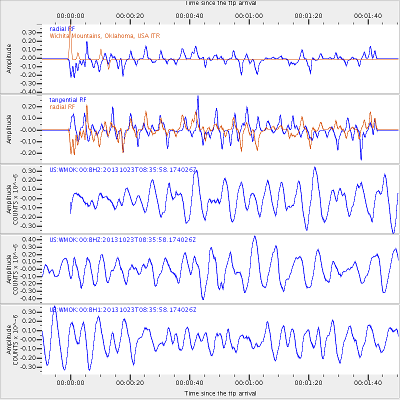
WMOK Wichita Mountains, Oklahoma, USA - Earthquake Result Viewer
*The percent match for this event was below the threshold and hence no stack was calculated.
| Earthquake location: |
South Of Fiji Islands |
| Earthquake latitude/longitude: |
-23.0/-177.1 |
| Earthquake time(UTC): |
2013/10/23 (296) 08:23:30 GMT |
| Earthquake Depth: |
160 km |
| Earthquake Magnitude: |
6.0 MWB, 6.0 MWC |
| Earthquake Catalog/Contributor: |
NEIC PDE/NEIC COMCAT |
|
| Network: |
US United States National Seismic Network |
| Station: |
WMOK Wichita Mountains, Oklahoma, USA |
| Lat/Lon: |
34.74 N/98.78 W |
| Elevation: |
486 m |
|
| Distance: |
93.9 deg |
| Az: |
53.945 deg |
| Baz: |
244.757 deg |
| Ray Param: |
$rayparam |
*The percent match for this event was below the threshold and hence was not used in the summary stack. |
|
| Radial Match: |
62.977997 % |
| Radial Bump: |
371 |
| Transverse Match: |
44.879143 % |
| Transverse Bump: |
400 |
| SOD ConfigId: |
626651 |
| Insert Time: |
2014-04-19 05:14:28.223 +0000 |
| GWidth: |
2.5 |
| Max Bumps: |
400 |
| Tol: |
0.001 |
|
Signal To Noise
| Channel | StoN | STA | LTA |
| US:WMOK:00:BHZ:20131023T08:35:58.174026Z | 1.3013878 | 1.190997E-7 | 9.151745E-8 |
| US:WMOK:00:BH1:20131023T08:35:58.174026Z | 1.125855 | 1.3511318E-7 | 1.200094E-7 |
| US:WMOK:00:BH2:20131023T08:35:58.174026Z | 2.0126503 | 1.13579276E-7 | 5.6432697E-8 |
| Arrivals |
| Ps | |
| PpPs | |
| PsPs/PpSs | |


