You are here: Home > Network List > II - Global Seismograph Network (GSN - IRIS/IDA) Stations List
> Station WRAB Tennant Creek, NT, Australia > Earthquake Result Viewer
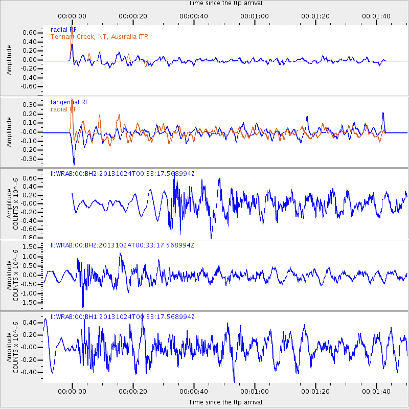
WRAB Tennant Creek, NT, Australia - Earthquake Result Viewer
*The percent match for this event was below the threshold and hence no stack was calculated.
| Earthquake location: |
Kermadec Islands, New Zealand |
| Earthquake latitude/longitude: |
-30.8/-178.2 |
| Earthquake time(UTC): |
2013/10/24 (297) 00:25:46 GMT |
| Earthquake Depth: |
49 km |
| Earthquake Magnitude: |
5.5 MWW, 5.5 MWW, 5.6 MWC |
| Earthquake Catalog/Contributor: |
NEIC PDE/NEIC COMCAT |
|
| Network: |
II Global Seismograph Network (GSN - IRIS/IDA) |
| Station: |
WRAB Tennant Creek, NT, Australia |
| Lat/Lon: |
19.93 S/134.36 E |
| Elevation: |
366 m |
|
| Distance: |
43.9 deg |
| Az: |
272.732 deg |
| Baz: |
114.037 deg |
| Ray Param: |
$rayparam |
*The percent match for this event was below the threshold and hence was not used in the summary stack. |
|
| Radial Match: |
77.37378 % |
| Radial Bump: |
400 |
| Transverse Match: |
61.53697 % |
| Transverse Bump: |
400 |
| SOD ConfigId: |
626651 |
| Insert Time: |
2014-04-19 05:23:43.232 +0000 |
| GWidth: |
2.5 |
| Max Bumps: |
400 |
| Tol: |
0.001 |
|
Signal To Noise
| Channel | StoN | STA | LTA |
| II:WRAB:00:BHZ:20131024T00:33:17.568994Z | 2.7260184 | 5.496477E-7 | 2.0163023E-7 |
| II:WRAB:00:BH1:20131024T00:33:17.568994Z | 0.53916067 | 1.3130935E-7 | 2.43544E-7 |
| II:WRAB:00:BH2:20131024T00:33:17.568994Z | 2.9653363 | 3.2796447E-7 | 1.1059942E-7 |
| Arrivals |
| Ps | |
| PpPs | |
| PsPs/PpSs | |


