You are here: Home > Network List > PF - Volcanologic Network of Piton de Fournaise-OVPF Stations List
> Station HIM cratere Himiltrude > Earthquake Result Viewer
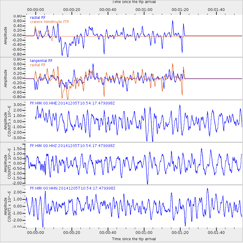
HIM cratere Himiltrude - Earthquake Result Viewer
*The percent match for this event was below the threshold and hence no stack was calculated.
| Earthquake location: |
Banda Sea |
| Earthquake latitude/longitude: |
-6.8/128.3 |
| Earthquake time(UTC): |
2014/12/05 (339) 10:43:55 GMT |
| Earthquake Depth: |
252 km |
| Earthquake Magnitude: |
5.1 MW, 5.1 mb |
| Earthquake Catalog/Contributor: |
ISC/ISC |
|
| Network: |
PF Volcanologic Network of Piton de Fournaise-OVPF |
| Station: |
HIM cratere Himiltrude |
| Lat/Lon: |
21.21 S/55.72 E |
| Elevation: |
1958 m |
|
| Distance: |
71.4 deg |
| Az: |
249.995 deg |
| Baz: |
90.215 deg |
| Ray Param: |
$rayparam |
*The percent match for this event was below the threshold and hence was not used in the summary stack. |
|
| Radial Match: |
50.718525 % |
| Radial Bump: |
400 |
| Transverse Match: |
40.867447 % |
| Transverse Bump: |
400 |
| SOD ConfigId: |
3390531 |
| Insert Time: |
2019-04-15 08:36:01.647 +0000 |
| GWidth: |
2.5 |
| Max Bumps: |
400 |
| Tol: |
0.001 |
|
Signal To Noise
| Channel | StoN | STA | LTA |
| PF:HIM:00:HHZ:20141205T10:54:17.479998Z | 0.7774372 | 3.9660546E-7 | 5.101447E-7 |
| PF:HIM:00:HHN:20141205T10:54:17.479998Z | 1.450166 | 1.2611739E-6 | 8.696756E-7 |
| PF:HIM:00:HHE:20141205T10:54:17.479998Z | 1.0544529 | 1.1681827E-6 | 1.1078567E-6 |
| Arrivals |
| Ps | |
| PpPs | |
| PsPs/PpSs | |


