You are here: Home > Network List > US - United States National Seismic Network Stations List
> Station MNTX Cornudas Mountains, Texas, USA > Earthquake Result Viewer
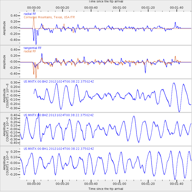
MNTX Cornudas Mountains, Texas, USA - Earthquake Result Viewer
*The percent match for this event was below the threshold and hence no stack was calculated.
| Earthquake location: |
Kermadec Islands, New Zealand |
| Earthquake latitude/longitude: |
-30.8/-178.2 |
| Earthquake time(UTC): |
2013/10/24 (297) 00:25:46 GMT |
| Earthquake Depth: |
49 km |
| Earthquake Magnitude: |
5.5 MWW, 5.5 MWW, 5.6 MWC |
| Earthquake Catalog/Contributor: |
NEIC PDE/NEIC COMCAT |
|
| Network: |
US United States National Seismic Network |
| Station: |
MNTX Cornudas Mountains, Texas, USA |
| Lat/Lon: |
31.70 N/105.38 W |
| Elevation: |
404 m |
|
| Distance: |
92.9 deg |
| Az: |
54.633 deg |
| Baz: |
235.38 deg |
| Ray Param: |
$rayparam |
*The percent match for this event was below the threshold and hence was not used in the summary stack. |
|
| Radial Match: |
72.77482 % |
| Radial Bump: |
400 |
| Transverse Match: |
57.130848 % |
| Transverse Bump: |
378 |
| SOD ConfigId: |
626651 |
| Insert Time: |
2014-04-19 05:28:03.742 +0000 |
| GWidth: |
2.5 |
| Max Bumps: |
400 |
| Tol: |
0.001 |
|
Signal To Noise
| Channel | StoN | STA | LTA |
| US:MNTX:00:BHZ:20131024T00:38:22.375024Z | 1.9326715 | 2.6602962E-7 | 1.3764864E-7 |
| US:MNTX:00:BH1:20131024T00:38:22.375024Z | 0.98612094 | 1.1760256E-7 | 1.1925775E-7 |
| US:MNTX:00:BH2:20131024T00:38:22.375024Z | 1.0647043 | 1.5657649E-7 | 1.4706102E-7 |
| Arrivals |
| Ps | |
| PpPs | |
| PsPs/PpSs | |


