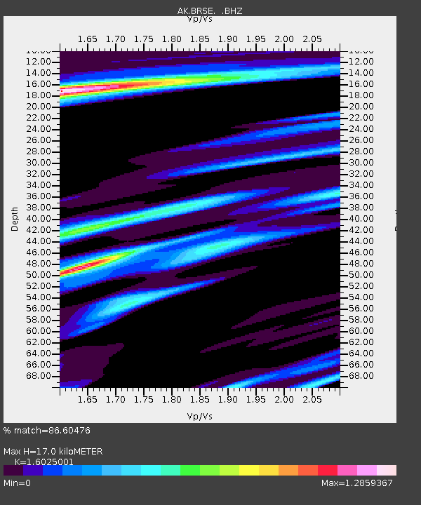
BRSE Bradley Lake South, AK, USA - Earthquake Result Viewer

Earthquake location: Off East Coast Of Honshu, Japan
Earthquake latitude/longitude: 37.2/144.7
Earthquake time(UTC): 2013/10/25 (298) 17:10:19 GMT
Earthquake Depth: 35 km
Earthquake Magnitude: 7.1 MWW, 7.1 MWW, 7.1 MWB, 7.1 MWC, 7.2 MWC, 7.5 MI
Earthquake Catalog/Contributor: NEIC PDE/NEIC COMCAT
Network: AK Alaska Regional Network
Station: BRSE Bradley Lake South, AK, USA
Lat/Lon: 59.74 N/150.74 W
Elevation: 541 m
Distance: 46.2 deg
Az: 39.333 deg
Baz: 270.718 deg
Ray Param: 0.070723034
Estimated Moho Depth: 17.0 km
Estimated Crust Vp/Vs: 1.60
Assumed Crust Vp: 6.24 km/s
Estimated Crust Vs: 3.894 km/s
Estimated Crust Poisson's Ratio: 0.18
Radial Match: 86.60476 %
Radial Bump: 373
Transverse Match: 70.109314 %
Transverse Bump: 400
SOD ConfigId: 626651
Insert Time: 2014-04-19 05:35:33.822 +0000
GWidth: 2.5
Max Bumps: 400
Tol: 0.001

Signal To Noise

ChannelStoNSTALTA
AK:BRSE: :BHZ:20131025T17:18:10.687997Z8.3927885.1166385E-66.096471E-7
AK:BRSE: :BHN:20131025T17:18:10.687997Z1.3390788.665549E-76.4712805E-7
AK:BRSE: :BHE:20131025T17:18:10.687997Z4.6803253.5683559E-67.624163E-7
Arrivals
Ps1.8 SECOND
PpPs6.6 SECOND
PsPs/PpSs8.4 SECOND