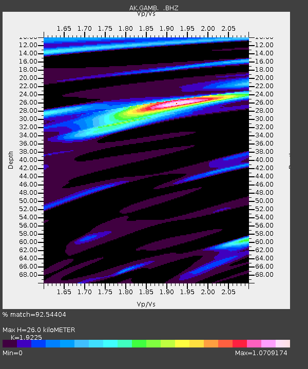
GAMB Gambell Broadband - Earthquake Result Viewer
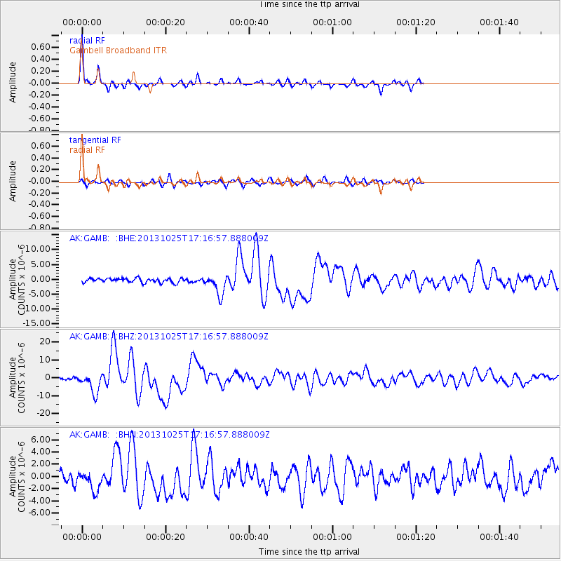
Earthquake location: Off East Coast Of Honshu, Japan
Earthquake latitude/longitude: 37.2/144.7
Earthquake time(UTC): 2013/10/25 (298) 17:10:19 GMT
Earthquake Depth: 35 km
Earthquake Magnitude: 7.1 MWW, 7.1 MWW, 7.1 MWB, 7.1 MWC, 7.2 MWC, 7.5 MI
Earthquake Catalog/Contributor: NEIC PDE/NEIC COMCAT
Network: AK Alaska Regional Network
Station: GAMB Gambell Broadband
Lat/Lon: 63.78 N/171.70 W
Elevation: 10 m
Distance: 37.3 deg
Az: 30.407 deg
Baz: 245.537 deg
Ray Param: 0.07615477
Estimated Moho Depth: 26.0 km
Estimated Crust Vp/Vs: 1.92
Assumed Crust Vp: 6.24 km/s
Estimated Crust Vs: 3.246 km/s
Estimated Crust Poisson's Ratio: 0.31
Radial Match: 92.54404 %
Radial Bump: 301
Transverse Match: 68.90655 %
Transverse Bump: 400
SOD ConfigId: 626651
Insert Time: 2014-04-19 05:36:18.403 +0000
GWidth: 2.5
Max Bumps: 400
Tol: 0.001

Signal To Noise

ChannelStoNSTALTA
AK:GAMB: :BHZ:20131025T17:16:57.888009Z6.13457255.6857516E-69.2683746E-7
AK:GAMB: :BHN:20131025T17:16:57.888009Z1.1949041.5899554E-61.3306136E-6
AK:GAMB: :BHE:20131025T17:16:57.888009Z5.0151063.476495E-66.932047E-7
Arrivals
Ps4.1 SECOND
PpPs11 SECOND
PsPs/PpSs16 SECOND