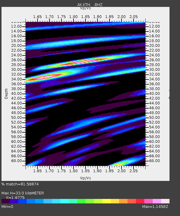
KTH Kantishna Hills - Earthquake Result Viewer

Earthquake location: Off East Coast Of Honshu, Japan
Earthquake latitude/longitude: 37.2/144.7
Earthquake time(UTC): 2013/10/25 (298) 17:10:19 GMT
Earthquake Depth: 35 km
Earthquake Magnitude: 7.1 MWW, 7.1 MWW, 7.1 MWB, 7.1 MWC, 7.2 MWC, 7.5 MI
Earthquake Catalog/Contributor: NEIC PDE/NEIC COMCAT
Network: AK Alaska Regional Network
Station: KTH Kantishna Hills
Lat/Lon: 63.55 N/150.92 W
Elevation: 1172 m
Distance: 46.2 deg
Az: 34.03 deg
Baz: 266.888 deg
Ray Param: 0.0707266
Estimated Moho Depth: 33.0 km
Estimated Crust Vp/Vs: 1.68
Assumed Crust Vp: 6.438 km/s
Estimated Crust Vs: 3.838 km/s
Estimated Crust Poisson's Ratio: 0.22
Radial Match: 91.56974 %
Radial Bump: 400
Transverse Match: 87.75145 %
Transverse Bump: 400
SOD ConfigId: 626651
Insert Time: 2014-04-19 05:36:49.627 +0000
GWidth: 2.5
Max Bumps: 400
Tol: 0.001

Signal To Noise

ChannelStoNSTALTA
AK:KTH: :BHZ:20131025T17:18:10.627999Z33.6590358.554015E-62.5413723E-7
AK:KTH: :BHN:20131025T17:18:10.627999Z1.57915544.5576934E-72.886159E-7
AK:KTH: :BHE:20131025T17:18:10.627999Z13.5230714.4869785E-63.3180171E-7
Arrivals
Ps3.7 SECOND
PpPs13 SECOND
PsPs/PpSs17 SECOND