You are here: Home > Network List > II - Global Seismograph Network (GSN - IRIS/IDA) Stations List
> Station TLY Talaya, Russia > Earthquake Result Viewer
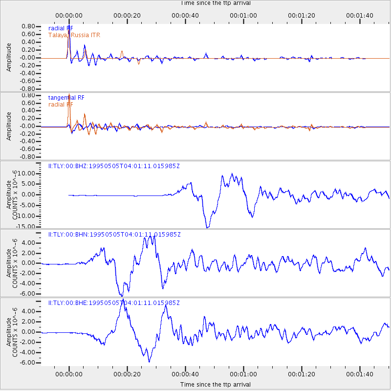
TLY Talaya, Russia - Earthquake Result Viewer

| Earthquake location: |
Samar, Philippines |
| Earthquake latitude/longitude: |
12.6/125.3 |
| Earthquake time(UTC): |
1995/05/05 (125) 03:53:47 GMT |
| Earthquake Depth: |
33 km |
| Earthquake Magnitude: |
6.2 MB, 7.0 MS, 7.1 UNKNOWN, 7.0 MW |
| Earthquake Catalog/Contributor: |
WHDF/NEIC |
|
| Network: |
II Global Seismograph Network (GSN - IRIS/IDA) |
| Station: |
TLY Talaya, Russia |
| Lat/Lon: |
51.68 N/103.64 E |
| Elevation: |
579 m |
|
| Distance: |
42.7 deg |
| Az: |
340.19 deg |
| Baz: |
147.904 deg |
| Ray Param: |
0.07294315 |
| Estimated Moho Depth: |
13.25 km |
| Estimated Crust Vp/Vs: |
1.81 |
| Assumed Crust Vp: |
6.419 km/s |
| Estimated Crust Vs: |
3.547 km/s |
| Estimated Crust Poisson's Ratio: |
0.28 |
|
| Radial Match: |
98.75627 % |
| Radial Bump: |
368 |
| Transverse Match: |
94.774025 % |
| Transverse Bump: |
400 |
| SOD ConfigId: |
61242 |
| Insert Time: |
2010-03-01 17:28:29.677 +0000 |
| GWidth: |
2.5 |
| Max Bumps: |
400 |
| Tol: |
0.001 |
|
Signal To Noise
| Channel | StoN | STA | LTA |
| II:TLY:00:BHN:19950505T04:01:11.015985Z | 2.245735 | 1.2367865E-7 | 5.5072686E-8 |
| II:TLY:00:BHE:19950505T04:01:11.015985Z | 1.8196335 | 7.644587E-8 | 4.2011685E-8 |
| II:TLY:00:BHZ:19950505T04:01:11.015985Z | 3.1605742 | 2.6144804E-7 | 8.272169E-8 |
| Arrivals |
| Ps | 1.8 SECOND |
| PpPs | 5.4 SECOND |
| PsPs/PpSs | 7.2 SECOND |


