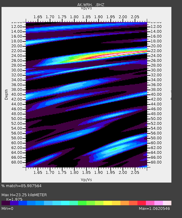
WRH Wood River Hill - Earthquake Result Viewer

Earthquake location: Off East Coast Of Honshu, Japan
Earthquake latitude/longitude: 37.2/144.7
Earthquake time(UTC): 2013/10/25 (298) 17:10:19 GMT
Earthquake Depth: 35 km
Earthquake Magnitude: 7.1 MWW, 7.1 MWW, 7.1 MWB, 7.1 MWC, 7.2 MWC, 7.5 MI
Earthquake Catalog/Contributor: NEIC PDE/NEIC COMCAT
Network: AK Alaska Regional Network
Station: WRH Wood River Hill
Lat/Lon: 64.47 N/148.09 W
Elevation: 343 m
Distance: 47.5 deg
Az: 32.833 deg
Baz: 268.612 deg
Ray Param: 0.06989354
Estimated Moho Depth: 23.25 km
Estimated Crust Vp/Vs: 1.98
Assumed Crust Vp: 6.566 km/s
Estimated Crust Vs: 3.325 km/s
Estimated Crust Poisson's Ratio: 0.33
Radial Match: 85.987564 %
Radial Bump: 360
Transverse Match: 78.41601 %
Transverse Bump: 344
SOD ConfigId: 626651
Insert Time: 2014-04-19 05:38:28.258 +0000
GWidth: 2.5
Max Bumps: 400
Tol: 0.001

Signal To Noise

ChannelStoNSTALTA
AK:WRH: :BHZ:20131025T17:18:20.647988Z25.9586267.598961E-62.9273357E-7
AK:WRH: :BHN:20131025T17:18:20.647988Z8.8007541.8532966E-62.1058383E-7
AK:WRH: :BHE:20131025T17:18:20.647988Z12.9626353.9953106E-63.0821747E-7
Arrivals
Ps3.7 SECOND
PpPs9.9 SECOND
PsPs/PpSs14 SECOND