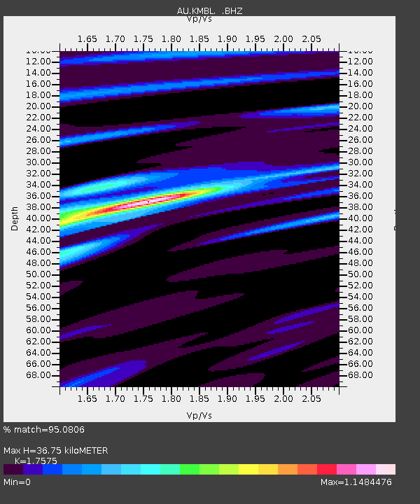
KMBL Kambalda, Western Australia - Earthquake Result Viewer

Earthquake location: Off East Coast Of Honshu, Japan
Earthquake latitude/longitude: 37.2/144.7
Earthquake time(UTC): 2013/10/25 (298) 17:10:19 GMT
Earthquake Depth: 35 km
Earthquake Magnitude: 7.1 MWW, 7.1 MWW, 7.1 MWB, 7.1 MWC, 7.2 MWC, 7.5 MI
Earthquake Catalog/Contributor: NEIC PDE/NEIC COMCAT
Network: AU Australian Seismological Centre
Station: KMBL Kambalda, Western Australia
Lat/Lon: 31.37 S/121.88 E
Elevation: 370 m
Distance: 71.4 deg
Az: 200.451 deg
Baz: 19.047 deg
Ray Param: 0.054284982
Estimated Moho Depth: 36.75 km
Estimated Crust Vp/Vs: 1.76
Assumed Crust Vp: 6.459 km/s
Estimated Crust Vs: 3.675 km/s
Estimated Crust Poisson's Ratio: 0.26
Radial Match: 95.0806 %
Radial Bump: 328
Transverse Match: 81.35971 %
Transverse Bump: 400
SOD ConfigId: 626651
Insert Time: 2014-04-19 05:39:13.987 +0000
GWidth: 2.5
Max Bumps: 400
Tol: 0.001

Signal To Noise

ChannelStoNSTALTA
AU:KMBL: :BHZ:20131025T17:21:05.493997Z10.8014366.710254E-66.2123723E-7
AU:KMBL: :BHN:20131025T17:21:05.493997Z7.93317132.9030148E-63.6593372E-7
AU:KMBL: :BHE:20131025T17:21:05.493997Z1.97738667.030455E-73.5554274E-7
Arrivals
Ps4.5 SECOND
PpPs15 SECOND
PsPs/PpSs20 SECOND