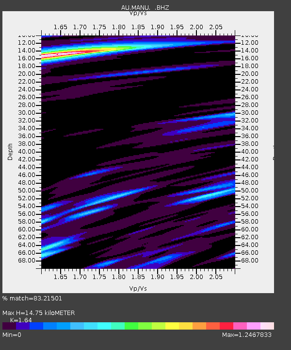
MANU Manus Island, Papau New Guinea - Earthquake Result Viewer

Earthquake location: Off East Coast Of Honshu, Japan
Earthquake latitude/longitude: 37.2/144.7
Earthquake time(UTC): 2013/10/25 (298) 17:10:19 GMT
Earthquake Depth: 35 km
Earthquake Magnitude: 7.1 MWW, 7.1 MWW, 7.1 MWB, 7.1 MWC, 7.2 MWC, 7.5 MI
Earthquake Catalog/Contributor: NEIC PDE/NEIC COMCAT
Network: AU Australian Seismological Centre
Station: MANU Manus Island, Papau New Guinea
Lat/Lon: 2.04 S/147.37 E
Elevation: 142 m
Distance: 39.1 deg
Az: 175.709 deg
Baz: 356.571 deg
Ray Param: 0.075121105
Estimated Moho Depth: 14.75 km
Estimated Crust Vp/Vs: 1.64
Assumed Crust Vp: 4.082 km/s
Estimated Crust Vs: 2.489 km/s
Estimated Crust Poisson's Ratio: 0.20
Radial Match: 83.21501 %
Radial Bump: 352
Transverse Match: 64.30829 %
Transverse Bump: 400
SOD ConfigId: 626651
Insert Time: 2014-04-19 05:39:19.342 +0000
GWidth: 2.5
Max Bumps: 400
Tol: 0.001

Signal To Noise

ChannelStoNSTALTA
AU:MANU: :BHZ:20131025T17:17:13.01899Z8.0325323.8689254E-64.816571E-7
AU:MANU: :BHN:20131025T17:17:13.01899Z6.02825162.216252E-63.6764422E-7
AU:MANU: :BHE:20131025T17:17:13.01899Z2.77765379.74927E-73.509894E-7
Arrivals
Ps2.4 SECOND
PpPs9.3 SECOND
PsPs/PpSs12 SECOND