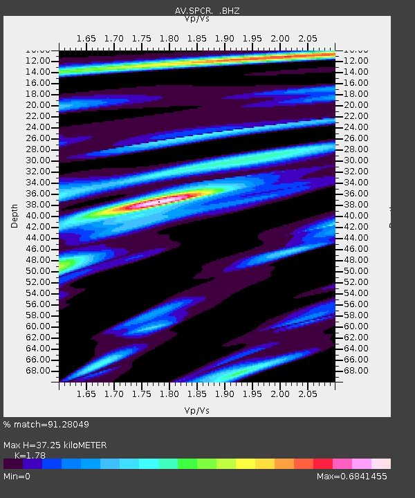
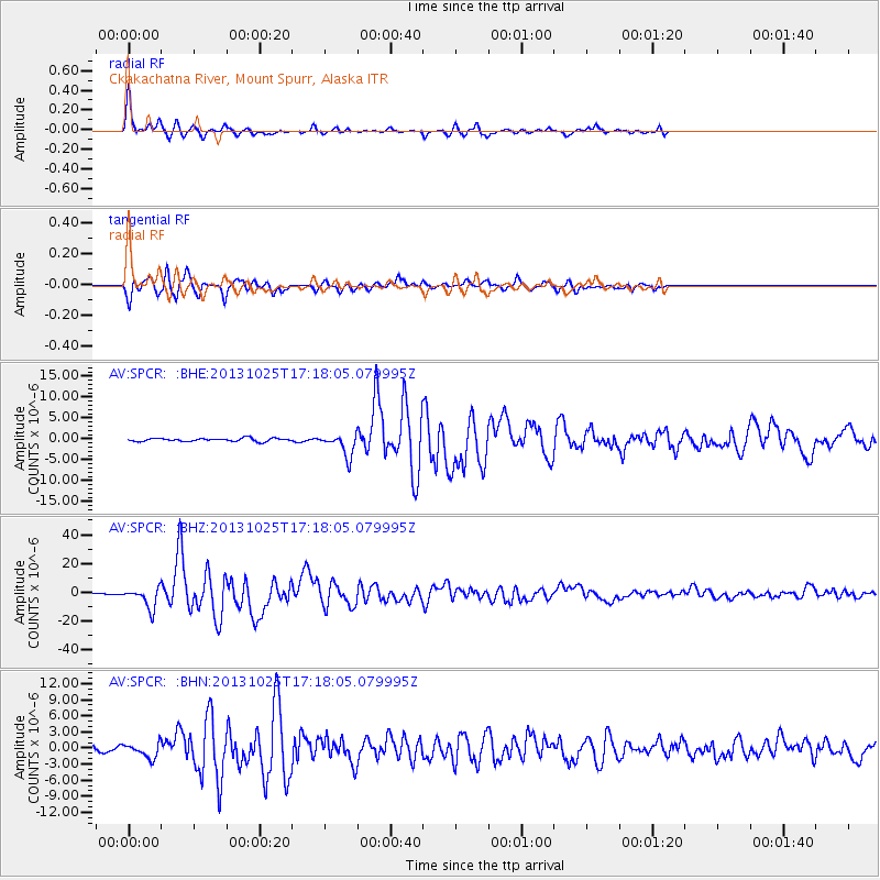
SPCR Ckakachatna River, Mount Spurr, Alaska - Earthquake Result Viewer

Earthquake location: Off East Coast Of Honshu, Japan
Earthquake latitude/longitude: 37.2/144.7
Earthquake time(UTC): 2013/10/25 (298) 17:10:19 GMT
Earthquake Depth: 35 km
Earthquake Magnitude: 7.1 MWW, 7.1 MWW, 7.1 MWB, 7.1 MWC, 7.2 MWC, 7.5 MI
Earthquake Catalog/Contributor: NEIC PDE/NEIC COMCAT
Network: AV Alaska Volcano Observatory
Station: SPCR Ckakachatna River, Mount Spurr, Alaska
Lat/Lon: 61.20 N/152.21 W
Elevation: 984 m
Distance: 45.5 deg
Az: 37.281 deg
Baz: 268.014 deg
Ray Param: 0.07117067
Estimated Moho Depth: 37.25 km
Estimated Crust Vp/Vs: 1.78
Assumed Crust Vp: 6.566 km/s
Estimated Crust Vs: 3.689 km/s
Estimated Crust Poisson's Ratio: 0.27
Radial Match: 91.28049 %
Radial Bump: 236
Transverse Match: 87.02663 %
Transverse Bump: 400
SOD ConfigId: 626651
Insert Time: 2014-04-19 05:41:01.158 +0000
GWidth: 2.5
Max Bumps: 400
Tol: 0.001

Signal To Noise

ChannelStoNSTALTA
AV:SPCR: :BHZ:20131025T17:18:05.079995Z14.7964977.088507E-64.7906656E-7
AV:SPCR: :BHN:20131025T17:18:05.079995Z3.5289551.3762121E-63.8997723E-7
AV:SPCR: :BHE:20131025T17:18:05.079995Z7.229612.667717E-63.6899874E-7
Arrivals
Ps4.7 SECOND
PpPs15 SECOND
PsPs/PpSs19 SECOND