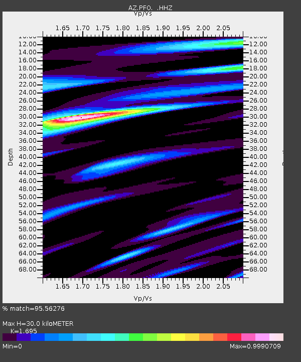
PFO AZ.PFO - Earthquake Result Viewer

Earthquake location: Off East Coast Of Honshu, Japan
Earthquake latitude/longitude: 37.2/144.7
Earthquake time(UTC): 2013/10/25 (298) 17:10:19 GMT
Earthquake Depth: 35 km
Earthquake Magnitude: 7.1 MWW, 7.1 MWW, 7.1 MWB, 7.1 MWC, 7.2 MWC, 7.5 MI
Earthquake Catalog/Contributor: NEIC PDE/NEIC COMCAT
Network: AZ ANZA Regional Network
Station: PFO AZ.PFO
Lat/Lon: 33.61 N/116.46 W
Elevation: 1259 m
Distance: 76.8 deg
Az: 57.877 deg
Baz: 305.825 deg
Ray Param: 0.05070438
Estimated Moho Depth: 30.0 km
Estimated Crust Vp/Vs: 1.70
Assumed Crust Vp: 6.264 km/s
Estimated Crust Vs: 3.695 km/s
Estimated Crust Poisson's Ratio: 0.23
Radial Match: 95.56276 %
Radial Bump: 400
Transverse Match: 88.753845 %
Transverse Bump: 400
SOD ConfigId: 626651
Insert Time: 2014-04-19 05:41:27.198 +0000
GWidth: 2.5
Max Bumps: 400
Tol: 0.001

Signal To Noise

ChannelStoNSTALTA
AZ:PFO: :HHZ:20131025T17:21:36.748025Z9.9118694.477439E-64.51725E-7
AZ:PFO: :HHN:20131025T17:21:36.748025Z3.1194561.157607E-63.710926E-7
AZ:PFO: :HHE:20131025T17:21:36.748025Z7.6571281.1325969E-61.4791408E-7
Arrivals
Ps3.4 SECOND
PpPs13 SECOND
PsPs/PpSs16 SECOND