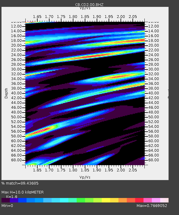
CD2 Chengdou,Sichuan Province - Earthquake Result Viewer

Earthquake location: Off East Coast Of Honshu, Japan
Earthquake latitude/longitude: 37.2/144.7
Earthquake time(UTC): 2013/10/25 (298) 17:10:19 GMT
Earthquake Depth: 35 km
Earthquake Magnitude: 7.1 MWW, 7.1 MWW, 7.1 MWB, 7.1 MWC, 7.2 MWC, 7.5 MI
Earthquake Catalog/Contributor: NEIC PDE/NEIC COMCAT
Network: CB China National Seismic Network
Station: CD2 Chengdou,Sichuan Province
Lat/Lon: 30.91 N/103.76 E
Elevation: 653 m
Distance: 34.3 deg
Az: 271.801 deg
Baz: 68.294 deg
Ray Param: 0.07776488
Estimated Moho Depth: 10.0 km
Estimated Crust Vp/Vs: 1.60
Assumed Crust Vp: 6.159 km/s
Estimated Crust Vs: 3.849 km/s
Estimated Crust Poisson's Ratio: 0.18
Radial Match: 89.43685 %
Radial Bump: 400
Transverse Match: 76.80254 %
Transverse Bump: 400
SOD ConfigId: 626651
Insert Time: 2014-04-19 05:42:24.889 +0000
GWidth: 2.5
Max Bumps: 400
Tol: 0.001

Signal To Noise

ChannelStoNSTALTA
CB:CD2:00:BHZ:20131025T17:16:32.130013Z13.8690977.956868E-65.7371204E-7
CB:CD2:00:BHN:20131025T17:16:32.130013Z4.33456131.2468658E-62.8765677E-7
CB:CD2:00:BHE:20131025T17:16:32.130013Z10.3927313.8989306E-63.751594E-7
Arrivals
Ps1.1 SECOND
PpPs3.9 SECOND
PsPs/PpSs5.0 SECOND