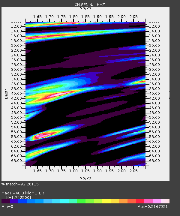
SENIN Lac Selin/Sanetsch - Earthquake Result Viewer

Earthquake location: Off East Coast Of Honshu, Japan
Earthquake latitude/longitude: 37.2/144.7
Earthquake time(UTC): 2013/10/25 (298) 17:10:19 GMT
Earthquake Depth: 35 km
Earthquake Magnitude: 7.1 MWW, 7.1 MWW, 7.1 MWB, 7.1 MWC, 7.2 MWC, 7.5 MI
Earthquake Catalog/Contributor: NEIC PDE/NEIC COMCAT
Network: CH Switzerland Seismological Network
Station: SENIN Lac Selin/Sanetsch
Lat/Lon: 46.36 N/7.30 E
Elevation: 2035 m
Distance: 88.5 deg
Az: 332.014 deg
Baz: 32.777 deg
Ray Param: 0.042522855
Estimated Moho Depth: 40.0 km
Estimated Crust Vp/Vs: 1.74
Assumed Crust Vp: 6.276 km/s
Estimated Crust Vs: 3.602 km/s
Estimated Crust Poisson's Ratio: 0.25
Radial Match: 92.26115 %
Radial Bump: 383
Transverse Match: 85.54134 %
Transverse Bump: 400
SOD ConfigId: 626651
Insert Time: 2014-04-19 05:43:15.096 +0000
GWidth: 2.5
Max Bumps: 400
Tol: 0.001

Signal To Noise

ChannelStoNSTALTA
CH:SENIN: :HHZ:20131025T17:22:37.145974Z14.7101083.7131683E-62.5242292E-7
CH:SENIN: :HHN:20131025T17:22:37.145974Z4.398251.2293295E-62.7950423E-7
CH:SENIN: :HHE:20131025T17:22:37.145974Z4.2109476.697532E-71.5905049E-7
Arrivals
Ps4.8 SECOND
PpPs17 SECOND
PsPs/PpSs22 SECOND