You are here: Home > Network List > TA - USArray Transportable Network (new EarthScope stations) Stations List
> Station T25A Trinidad, CO, USA > Earthquake Result Viewer
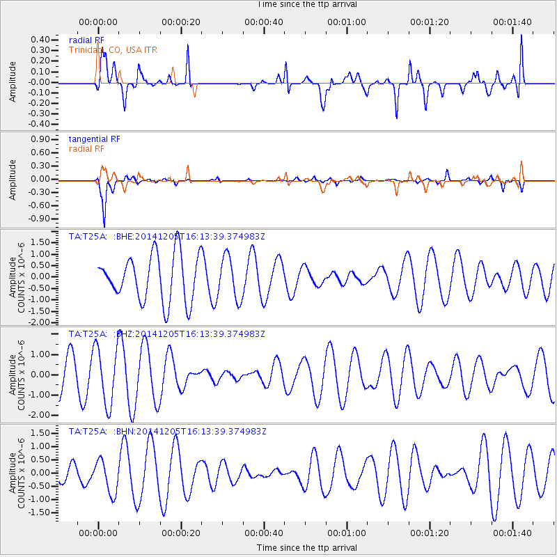
T25A Trinidad, CO, USA - Earthquake Result Viewer
*The percent match for this event was below the threshold and hence no stack was calculated.
| Earthquake location: |
Western Honshu, Japan |
| Earthquake latitude/longitude: |
35.5/135.7 |
| Earthquake time(UTC): |
2014/12/05 (339) 16:01:56 GMT |
| Earthquake Depth: |
355 km |
| Earthquake Magnitude: |
5.3 MW, 5.0 mb |
| Earthquake Catalog/Contributor: |
ISC/ISC |
|
| Network: |
TA USArray Transportable Network (new EarthScope stations) |
| Station: |
T25A Trinidad, CO, USA |
| Lat/Lon: |
37.14 N/104.41 W |
| Elevation: |
2017 m |
|
| Distance: |
88.7 deg |
| Az: |
43.88 deg |
| Baz: |
314.958 deg |
| Ray Param: |
$rayparam |
*The percent match for this event was below the threshold and hence was not used in the summary stack. |
|
| Radial Match: |
71.457115 % |
| Radial Bump: |
400 |
| Transverse Match: |
89.87393 % |
| Transverse Bump: |
273 |
| SOD ConfigId: |
3390531 |
| Insert Time: |
2019-04-15 08:43:54.296 +0000 |
| GWidth: |
2.5 |
| Max Bumps: |
400 |
| Tol: |
0.001 |
|
Signal To Noise
| Channel | StoN | STA | LTA |
| TA:T25A: :BHZ:20141205T16:13:39.374983Z | 1.8980803 | 1.4262014E-6 | 7.513915E-7 |
| TA:T25A: :BHN:20141205T16:13:39.374983Z | 0.9461644 | 6.462802E-7 | 6.8305275E-7 |
| TA:T25A: :BHE:20141205T16:13:39.374983Z | 0.92575127 | 9.372618E-7 | 1.0124337E-6 |
| Arrivals |
| Ps | |
| PpPs | |
| PsPs/PpSs | |


