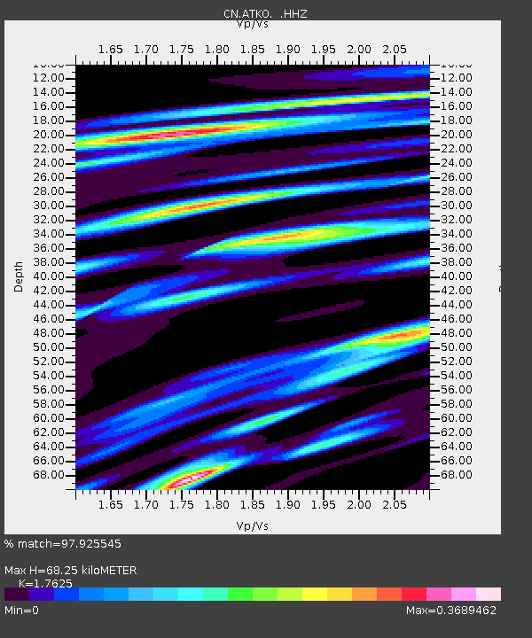
ATKO ATIKOKAN IRON MINE, ON - Earthquake Result Viewer

Earthquake location: Off East Coast Of Honshu, Japan
Earthquake latitude/longitude: 37.2/144.7
Earthquake time(UTC): 2013/10/25 (298) 17:10:19 GMT
Earthquake Depth: 35 km
Earthquake Magnitude: 7.1 MWW, 7.1 MWW, 7.1 MWB, 7.1 MWC, 7.2 MWC, 7.5 MI
Earthquake Catalog/Contributor: NEIC PDE/NEIC COMCAT
Network: CN Canadian National Seismograph Network
Station: ATKO ATIKOKAN IRON MINE, ON
Lat/Lon: 48.82 N/91.60 W
Elevation: 383 m
Distance: 80.9 deg
Az: 33.82 deg
Baz: 317.713 deg
Ray Param: 0.047911987
Estimated Moho Depth: 68.25 km
Estimated Crust Vp/Vs: 1.76
Assumed Crust Vp: 6.467 km/s
Estimated Crust Vs: 3.669 km/s
Estimated Crust Poisson's Ratio: 0.26
Radial Match: 97.925545 %
Radial Bump: 224
Transverse Match: 92.251465 %
Transverse Bump: 400
SOD ConfigId: 626651
Insert Time: 2014-04-19 05:44:49.074 +0000
GWidth: 2.5
Max Bumps: 400
Tol: 0.001

Signal To Noise

ChannelStoNSTALTA
CN:ATKO: :HHZ:20131025T17:21:59.22001Z18.0203081.7251405E-69.5733135E-8
CN:ATKO: :HHN:20131025T17:21:59.22001Z9.2796135.675343E-76.115927E-8
CN:ATKO: :HHE:20131025T17:21:59.22001Z6.38662054.5715765E-77.158052E-8
Arrivals
Ps8.3 SECOND
PpPs28 SECOND
PsPs/PpSs37 SECOND