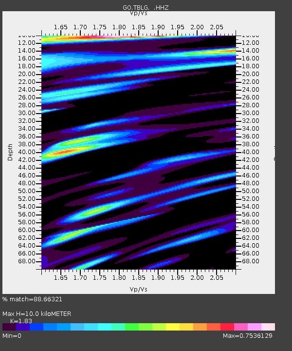
TBLG Delisi, Georgia - Earthquake Result Viewer
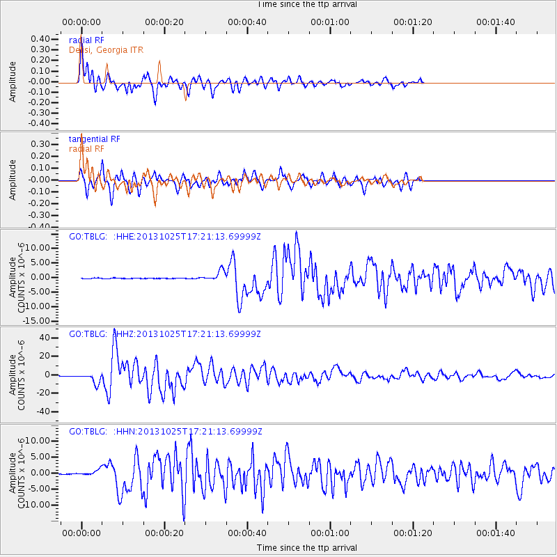
Earthquake location: Off East Coast Of Honshu, Japan
Earthquake latitude/longitude: 37.2/144.7
Earthquake time(UTC): 2013/10/25 (298) 17:10:19 GMT
Earthquake Depth: 35 km
Earthquake Magnitude: 7.1 MWW, 7.1 MWW, 7.1 MWB, 7.1 MWC, 7.2 MWC, 7.5 MI
Earthquake Catalog/Contributor: NEIC PDE/NEIC COMCAT
Network: GO National Seismic Network of Georgia
Station: TBLG Delisi, Georgia
Lat/Lon: 41.73 N/44.74 E
Elevation: 510 m
Distance: 72.8 deg
Az: 309.482 deg
Baz: 55.472 deg
Ray Param: 0.05337277
Estimated Moho Depth: 10.0 km
Estimated Crust Vp/Vs: 1.83
Assumed Crust Vp: 6.291 km/s
Estimated Crust Vs: 3.438 km/s
Estimated Crust Poisson's Ratio: 0.29
Radial Match: 88.66321 %
Radial Bump: 400
Transverse Match: 78.83563 %
Transverse Bump: 400
SOD ConfigId: 626651
Insert Time: 2014-04-19 05:49:15.861 +0000
GWidth: 2.5
Max Bumps: 400
Tol: 0.001

Signal To Noise

ChannelStoNSTALTA
GO:TBLG: :HHZ:20131025T17:21:13.69999Z72.526425.8753562E-68.100987E-8
GO:TBLG: :HHN:20131025T17:21:13.69999Z12.3242128.9246527E-77.24156E-8
GO:TBLG: :HHE:20131025T17:21:13.69999Z18.0087091.871107E-61.0390012E-7
Arrivals
Ps1.4 SECOND
PpPs4.4 SECOND
PsPs/PpSs5.7 SECOND